You are here: Home > Network List > TA - USArray Transportable Network (new EarthScope stations) Stations List
> Station M22A Cedar Creek Ranch, Saratoga, WY, USA > Earthquake Result Viewer
M22A Cedar Creek Ranch, Saratoga, WY, USA - Earthquake Result Viewer
| Earthquake location: |
Andreanof Islands, Aleutian Is. |
| Earthquake latitude/longitude: |
52.2/-178.7 |
| Earthquake time(UTC): |
2008/03/22 (082) 21:24:11 GMT |
| Earthquake Depth: |
132 km |
| Earthquake Magnitude: |
5.8 MB, 6.2 MW, 6.1 MW |
| Earthquake Catalog/Contributor: |
WHDF/NEIC |
|
| Network: |
TA USArray Transportable Network (new EarthScope stations) |
| Station: |
M22A Cedar Creek Ranch, Saratoga, WY, USA |
| Lat/Lon: |
41.40 N/106.60 W |
| Elevation: |
2334 m |
|
| Distance: |
48.6 deg |
| Az: |
72.644 deg |
| Baz: |
308.618 deg |
| Ray Param: |
0.06878529 |
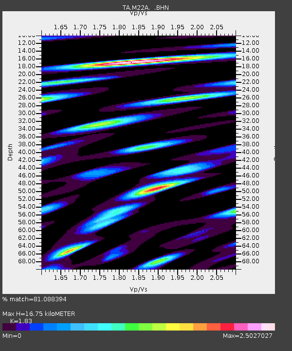
| Estimated Moho Depth: |
16.75 km |
| Estimated Crust Vp/Vs: |
1.83 |
| Assumed Crust Vp: |
6.159 km/s |
| Estimated Crust Vs: |
3.365 km/s |
| Estimated Crust Poisson's Ratio: |
0.29 |
|
| Radial Match: |
81.088394 % |
| Radial Bump: |
400 |
| Transverse Match: |
73.57145 % |
| Transverse Bump: |
400 |
| SOD ConfigId: |
2564 |
| Insert Time: |
2010-03-06 07:04:55.945 +0000 |
| GWidth: |
2.5 |
| Max Bumps: |
400 |
| Tol: |
0.001 |
|
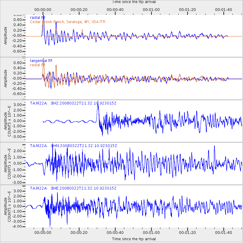
Signal To Noise
| Channel | StoN | STA | LTA |
| TA:M22A: :BHN:20080322T21:32:10.923015Z | 3.585711 | 7.621568E-7 | 2.1255387E-7 |
| TA:M22A: :BHE:20080322T21:32:10.923015Z | 6.392678 | 1.1525251E-6 | 1.8028831E-7 |
| TA:M22A: :BHZ:20080322T21:32:10.923015Z | 9.885653 | 1.4900631E-6 | 1.5072987E-7 |
| Arrivals |
| Ps | 2.4 SECOND |
| PpPs | 7.3 SECOND |
| PsPs/PpSs | 9.7 SECOND |


