You are here: Home > Network List > TA - USArray Transportable Network (new EarthScope stations) Stations List
> Station M22A Cedar Creek Ranch, Saratoga, WY, USA > Earthquake Result Viewer
M22A Cedar Creek Ranch, Saratoga, WY, USA - Earthquake Result Viewer
| Earthquake location: |
Near S. Coast Of Honshu, Japan |
| Earthquake latitude/longitude: |
33.2/137.9 |
| Earthquake time(UTC): |
2009/08/09 (221) 10:55:55 GMT |
| Earthquake Depth: |
297 km |
| Earthquake Magnitude: |
6.5 MB, 7.1 MW, 7.1 MW |
| Earthquake Catalog/Contributor: |
WHDF/NEIC |
|
| Network: |
TA USArray Transportable Network (new EarthScope stations) |
| Station: |
M22A Cedar Creek Ranch, Saratoga, WY, USA |
| Lat/Lon: |
41.40 N/106.60 W |
| Elevation: |
2334 m |
|
| Distance: |
85.0 deg |
| Az: |
42.985 deg |
| Baz: |
310.519 deg |
| Ray Param: |
0.04434472 |
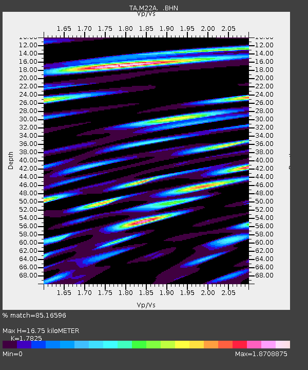
| Estimated Moho Depth: |
16.75 km |
| Estimated Crust Vp/Vs: |
1.78 |
| Assumed Crust Vp: |
6.159 km/s |
| Estimated Crust Vs: |
3.455 km/s |
| Estimated Crust Poisson's Ratio: |
0.27 |
|
| Radial Match: |
85.16596 % |
| Radial Bump: |
400 |
| Transverse Match: |
81.82258 % |
| Transverse Bump: |
400 |
| SOD ConfigId: |
2622 |
| Insert Time: |
2010-03-06 07:05:13.068 +0000 |
| GWidth: |
2.5 |
| Max Bumps: |
400 |
| Tol: |
0.001 |
|
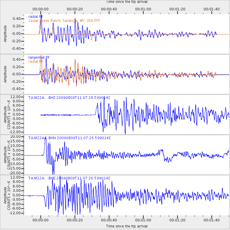
Signal To Noise
| Channel | StoN | STA | LTA |
| TA:M22A: :BHN:20090809T11:07:26.599014Z | 82.571396 | 8.520898E-6 | 1.031943E-7 |
| TA:M22A: :BHE:20090809T11:07:26.599014Z | 40.44673 | 3.4267243E-6 | 8.472191E-8 |
| TA:M22A: :BHZ:20090809T11:07:26.599014Z | 33.334423 | 2.877643E-6 | 8.632647E-8 |
| Arrivals |
| Ps | 2.2 SECOND |
| PpPs | 7.4 SECOND |
| PsPs/PpSs | 9.6 SECOND |


