You are here: Home > Network List > TA - USArray Transportable Network (new EarthScope stations) Stations List
> Station A36M Sachs Harbour, NT, CAN > Earthquake Result Viewer
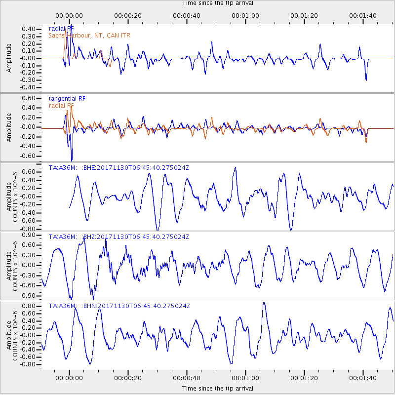
A36M Sachs Harbour, NT, CAN - Earthquake Result Viewer
*The percent match for this event was below the threshold and hence no stack was calculated.
| Earthquake location: |
Central Mid-Atlantic Ridge |
| Earthquake latitude/longitude: |
-1.1/-23.5 |
| Earthquake time(UTC): |
2017/11/30 (334) 06:32:52 GMT |
| Earthquake Depth: |
10 km |
| Earthquake Magnitude: |
6.5 Mi |
| Earthquake Catalog/Contributor: |
NEIC PDE/at |
|
| Network: |
TA USArray Transportable Network (new EarthScope stations) |
| Station: |
A36M Sachs Harbour, NT, CAN |
| Lat/Lon: |
71.99 N/125.25 W |
| Elevation: |
32 m |
|
| Distance: |
94.7 deg |
| Az: |
342.205 deg |
| Baz: |
79.155 deg |
| Ray Param: |
$rayparam |
*The percent match for this event was below the threshold and hence was not used in the summary stack. |
|
| Radial Match: |
58.90978 % |
| Radial Bump: |
400 |
| Transverse Match: |
76.38413 % |
| Transverse Bump: |
400 |
| SOD ConfigId: |
13570011 |
| Insert Time: |
2019-04-29 08:32:10.812 +0000 |
| GWidth: |
2.5 |
| Max Bumps: |
400 |
| Tol: |
0.001 |
|
Signal To Noise
| Channel | StoN | STA | LTA |
| TA:A36M: :BHZ:20171130T06:45:40.275024Z | 2.565173 | 6.41056E-7 | 2.4990752E-7 |
| TA:A36M: :BHN:20171130T06:45:40.275024Z | 2.701566 | 4.7616686E-7 | 1.7625587E-7 |
| TA:A36M: :BHE:20171130T06:45:40.275024Z | 1.8485551 | 4.1913566E-7 | 2.267369E-7 |
| Arrivals |
| Ps | |
| PpPs | |
| PsPs/PpSs | |


