You are here: Home > Network List > US - United States National Seismic Network Stations List
> Station HLID Hailey, Idaho, USA > Earthquake Result Viewer
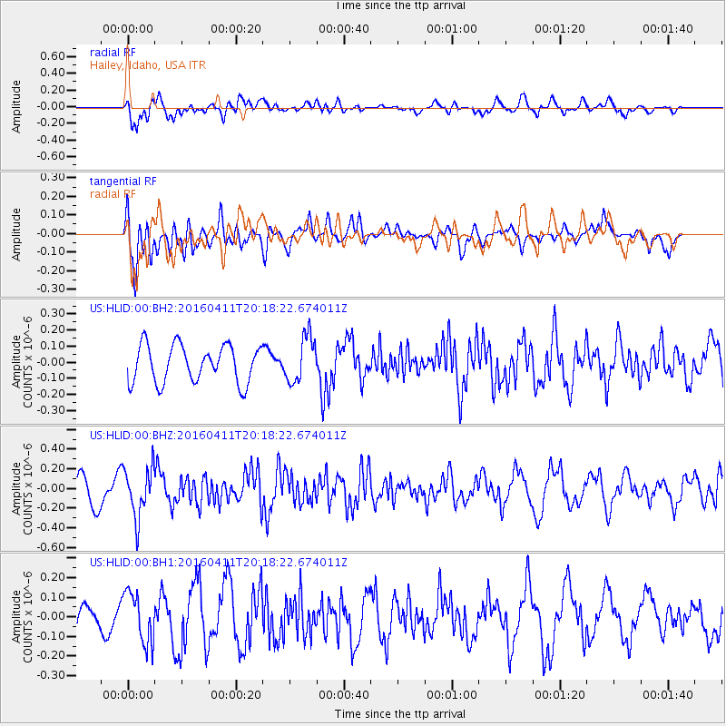
HLID Hailey, Idaho, USA - Earthquake Result Viewer
*The percent match for this event was below the threshold and hence no stack was calculated.
| Earthquake location: |
Rat Islands, Aleutian Islands |
| Earthquake latitude/longitude: |
51.8/176.6 |
| Earthquake time(UTC): |
2016/04/11 (102) 20:10:35 GMT |
| Earthquake Depth: |
22 km |
| Earthquake Magnitude: |
5.6 MB, 5.5 MB, 5.6 MI |
| Earthquake Catalog/Contributor: |
NEIC PDE/NEIC COMCAT |
|
| Network: |
US United States National Seismic Network |
| Station: |
HLID Hailey, Idaho, USA |
| Lat/Lon: |
43.56 N/114.41 W |
| Elevation: |
1772 m |
|
| Distance: |
45.5 deg |
| Az: |
71.93 deg |
| Baz: |
305.773 deg |
| Ray Param: |
$rayparam |
*The percent match for this event was below the threshold and hence was not used in the summary stack. |
|
| Radial Match: |
66.797325 % |
| Radial Bump: |
400 |
| Transverse Match: |
54.785053 % |
| Transverse Bump: |
400 |
| SOD ConfigId: |
1475611 |
| Insert Time: |
2016-04-25 20:27:07.780 +0000 |
| GWidth: |
2.5 |
| Max Bumps: |
400 |
| Tol: |
0.001 |
|
Signal To Noise
| Channel | StoN | STA | LTA |
| US:HLID:00:BHZ:20160411T20:18:22.674011Z | 1.9471986 | 2.5187472E-7 | 1.2935234E-7 |
| US:HLID:00:BH1:20160411T20:18:22.674011Z | 1.6401963 | 1.2978458E-7 | 7.912747E-8 |
| US:HLID:00:BH2:20160411T20:18:22.674011Z | 1.2507608 | 1.4436436E-7 | 1.1542123E-7 |
| Arrivals |
| Ps | |
| PpPs | |
| PsPs/PpSs | |


