You are here: Home > Network List > AV - Alaska Volcano Observatory Stations List
> Station SPCR Ckakachatna River, Mount Spurr, Alaska > Earthquake Result Viewer
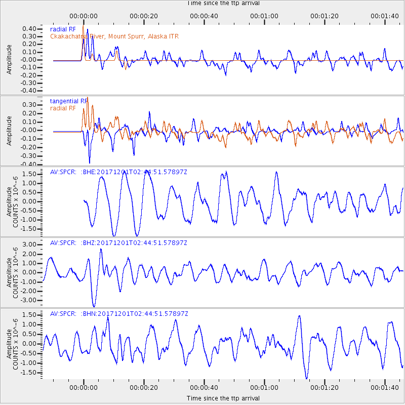
SPCR Ckakachatna River, Mount Spurr, Alaska - Earthquake Result Viewer
*The percent match for this event was below the threshold and hence no stack was calculated.
| Earthquake location: |
Northern And Central Iran |
| Earthquake latitude/longitude: |
30.7/57.3 |
| Earthquake time(UTC): |
2017/12/01 (335) 02:32:46 GMT |
| Earthquake Depth: |
9.0 km |
| Earthquake Magnitude: |
6.1 Mww |
| Earthquake Catalog/Contributor: |
NEIC PDE/us |
|
| Network: |
AV Alaska Volcano Observatory |
| Station: |
SPCR Ckakachatna River, Mount Spurr, Alaska |
| Lat/Lon: |
61.20 N/152.21 W |
| Elevation: |
984 m |
|
| Distance: |
85.3 deg |
| Az: |
13.853 deg |
| Baz: |
334.805 deg |
| Ray Param: |
$rayparam |
*The percent match for this event was below the threshold and hence was not used in the summary stack. |
|
| Radial Match: |
65.76675 % |
| Radial Bump: |
400 |
| Transverse Match: |
84.44653 % |
| Transverse Bump: |
395 |
| SOD ConfigId: |
13570011 |
| Insert Time: |
2019-04-29 08:35:38.303 +0000 |
| GWidth: |
2.5 |
| Max Bumps: |
400 |
| Tol: |
0.001 |
|
Signal To Noise
| Channel | StoN | STA | LTA |
| AV:SPCR: :BHZ:20171201T02:44:51.57897Z | 1.8880178 | 1.8378602E-6 | 9.734338E-7 |
| AV:SPCR: :BHN:20171201T02:44:51.57897Z | 0.62198156 | 4.8229145E-7 | 7.7541114E-7 |
| AV:SPCR: :BHE:20171201T02:44:51.57897Z | 0.6250553 | 7.0608615E-7 | 1.1296379E-6 |
| Arrivals |
| Ps | |
| PpPs | |
| PsPs/PpSs | |


