You are here: Home > Network List > TA - USArray Transportable Network (new EarthScope stations) Stations List
> Station M22A Cedar Creek Ranch, Saratoga, WY, USA > Earthquake Result Viewer
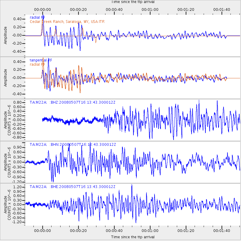
M22A Cedar Creek Ranch, Saratoga, WY, USA - Earthquake Result Viewer
*The percent match for this event was below the threshold and hence no stack was calculated.
| Earthquake location: |
Near East Coast Of Honshu, Japan |
| Earthquake latitude/longitude: |
36.2/141.5 |
| Earthquake time(UTC): |
2008/05/07 (128) 16:02:02 GMT |
| Earthquake Depth: |
19 km |
| Earthquake Magnitude: |
5.7 MB, 6.2 MW, 6.2 MW |
| Earthquake Catalog/Contributor: |
WHDF/NEIC |
|
| Network: |
TA USArray Transportable Network (new EarthScope stations) |
| Station: |
M22A Cedar Creek Ranch, Saratoga, WY, USA |
| Lat/Lon: |
41.40 N/106.60 W |
| Elevation: |
2334 m |
|
| Distance: |
80.8 deg |
| Az: |
45.021 deg |
| Baz: |
310.467 deg |
| Ray Param: |
$rayparam |
*The percent match for this event was below the threshold and hence was not used in the summary stack. |
|
| Radial Match: |
77.44073 % |
| Radial Bump: |
400 |
| Transverse Match: |
78.93729 % |
| Transverse Bump: |
400 |
| SOD ConfigId: |
2504 |
| Insert Time: |
2010-03-06 07:06:30.028 +0000 |
| GWidth: |
2.5 |
| Max Bumps: |
400 |
| Tol: |
0.001 |
|
Signal To Noise
| Channel | StoN | STA | LTA |
| TA:M22A: :BHN:20080507T16:13:43.300012Z | 4.366752 | 2.5611678E-7 | 5.8651555E-8 |
| TA:M22A: :BHE:20080507T16:13:43.300012Z | 1.1275828 | 1.0371325E-7 | 9.197839E-8 |
| TA:M22A: :BHZ:20080507T16:13:43.300012Z | 1.1892807 | 9.657943E-8 | 8.120826E-8 |
| Arrivals |
| Ps | |
| PpPs | |
| PsPs/PpSs | |


