You are here: Home > Network List > AU - Australian Seismological Centre Stations List
> Station PSAC1 Pilbara Seismic Array Element C1 > Earthquake Result Viewer
PSAC1 Pilbara Seismic Array Element C1 - Earthquake Result Viewer
| Earthquake location: |
Myanmar-India Border Region |
| Earthquake latitude/longitude: |
23.1/94.9 |
| Earthquake time(UTC): |
2016/04/13 (104) 13:55:17 GMT |
| Earthquake Depth: |
135 km |
| Earthquake Magnitude: |
6.9 MWB |
| Earthquake Catalog/Contributor: |
NEIC PDE/NEIC COMCAT |
|
| Network: |
AU Australian Seismological Centre |
| Station: |
PSAC1 Pilbara Seismic Array Element C1 |
| Lat/Lon: |
21.53 S/119.81 E |
| Elevation: |
303 m |
|
| Distance: |
50.6 deg |
| Az: |
149.502 deg |
| Baz: |
329.882 deg |
| Ray Param: |
0.06749986 |
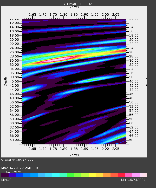
| Estimated Moho Depth: |
29.5 km |
| Estimated Crust Vp/Vs: |
1.76 |
| Assumed Crust Vp: |
6.464 km/s |
| Estimated Crust Vs: |
3.678 km/s |
| Estimated Crust Poisson's Ratio: |
0.26 |
|
| Radial Match: |
95.65779 % |
| Radial Bump: |
400 |
| Transverse Match: |
77.76652 % |
| Transverse Bump: |
400 |
| SOD ConfigId: |
1475611 |
| Insert Time: |
2016-04-27 13:56:33.841 +0000 |
| GWidth: |
2.5 |
| Max Bumps: |
400 |
| Tol: |
0.001 |
|

Signal To Noise
| Channel | StoN | STA | LTA |
| AU:PSAC1:00:BHZ:20160413T14:03:32.343999Z | 152.79028 | 2.9255365E-5 | 1.9147399E-7 |
| AU:PSAC1:00:BH1:20160413T14:03:32.343999Z | 65.168434 | 1.0774644E-5 | 1.6533531E-7 |
| AU:PSAC1:00:BH2:20160413T14:03:32.343999Z | 60.340183 | 6.606735E-6 | 1.0949146E-7 |
| Arrivals |
| Ps | 3.7 SECOND |
| PpPs | 12 SECOND |
| PsPs/PpSs | 16 SECOND |


