You are here: Home > Network List > TA - USArray Transportable Network (new EarthScope stations) Stations List
> Station M22A Cedar Creek Ranch, Saratoga, WY, USA > Earthquake Result Viewer
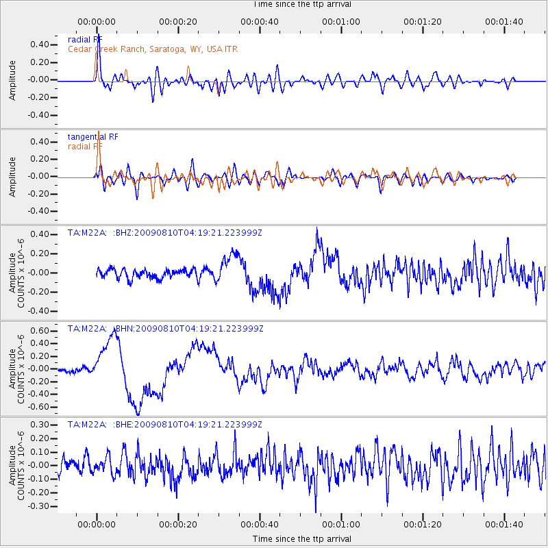
M22A Cedar Creek Ranch, Saratoga, WY, USA - Earthquake Result Viewer
*The percent match for this event was below the threshold and hence no stack was calculated.
| Earthquake location: |
Santa Cruz Islands |
| Earthquake latitude/longitude: |
-11.6/166.1 |
| Earthquake time(UTC): |
2009/08/10 (222) 04:06:31 GMT |
| Earthquake Depth: |
35 km |
| Earthquake Magnitude: |
5.8 MB, 6.3 MS, 6.6 MW, 6.6 MW |
| Earthquake Catalog/Contributor: |
WHDF/NEIC |
|
| Network: |
TA USArray Transportable Network (new EarthScope stations) |
| Station: |
M22A Cedar Creek Ranch, Saratoga, WY, USA |
| Lat/Lon: |
41.40 N/106.60 W |
| Elevation: |
2334 m |
|
| Distance: |
95.6 deg |
| Az: |
49.027 deg |
| Baz: |
259.54 deg |
| Ray Param: |
$rayparam |
*The percent match for this event was below the threshold and hence was not used in the summary stack. |
|
| Radial Match: |
77.94265 % |
| Radial Bump: |
400 |
| Transverse Match: |
58.594723 % |
| Transverse Bump: |
400 |
| SOD ConfigId: |
2622 |
| Insert Time: |
2010-03-06 07:07:09.621 +0000 |
| GWidth: |
2.5 |
| Max Bumps: |
400 |
| Tol: |
0.001 |
|
Signal To Noise
| Channel | StoN | STA | LTA |
| TA:M22A: :BHN:20090810T04:19:21.223999Z | 8.739831 | 3.9910216E-7 | 4.566475E-8 |
| TA:M22A: :BHE:20090810T04:19:21.223999Z | 1.1424952 | 6.276842E-8 | 5.4939765E-8 |
| TA:M22A: :BHZ:20090810T04:19:21.223999Z | 3.5034435 | 1.5820952E-7 | 4.5158288E-8 |
| Arrivals |
| Ps | |
| PpPs | |
| PsPs/PpSs | |


