You are here: Home > Network List > MM - Myanmar National Seismic Network Stations List
> Station MDY Mandalay, Mandalay, Myanmar > Earthquake Result Viewer
MDY Mandalay, Mandalay, Myanmar - Earthquake Result Viewer
| Earthquake location: |
Northern And Central Iran |
| Earthquake latitude/longitude: |
30.7/57.3 |
| Earthquake time(UTC): |
2017/12/01 (335) 02:32:46 GMT |
| Earthquake Depth: |
9.0 km |
| Earthquake Magnitude: |
6.1 Mww |
| Earthquake Catalog/Contributor: |
NEIC PDE/us |
|
| Network: |
MM Myanmar National Seismic Network |
| Station: |
MDY Mandalay, Mandalay, Myanmar |
| Lat/Lon: |
22.02 N/96.11 E |
| Elevation: |
97 m |
|
| Distance: |
35.7 deg |
| Az: |
94.618 deg |
| Baz: |
292.36 deg |
| Ray Param: |
0.077092685 |
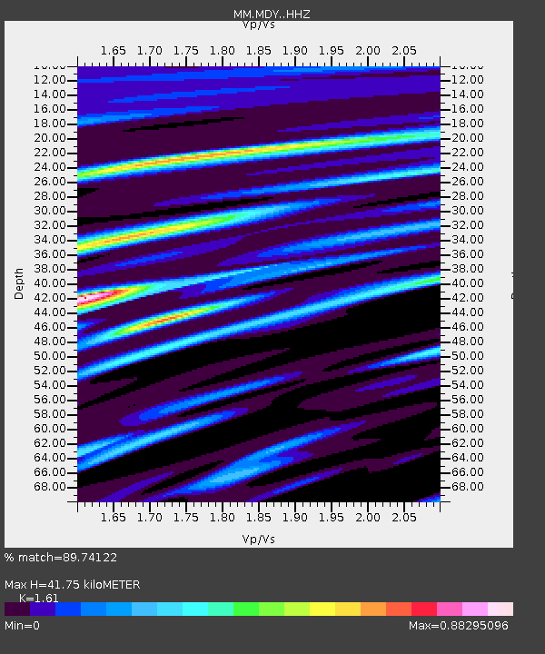
| Estimated Moho Depth: |
41.75 km |
| Estimated Crust Vp/Vs: |
1.61 |
| Assumed Crust Vp: |
6.316 km/s |
| Estimated Crust Vs: |
3.923 km/s |
| Estimated Crust Poisson's Ratio: |
0.19 |
|
| Radial Match: |
89.74122 % |
| Radial Bump: |
400 |
| Transverse Match: |
71.471596 % |
| Transverse Bump: |
400 |
| SOD ConfigId: |
13570011 |
| Insert Time: |
2019-04-29 08:38:13.397 +0000 |
| GWidth: |
2.5 |
| Max Bumps: |
400 |
| Tol: |
0.001 |
|

Signal To Noise
| Channel | StoN | STA | LTA |
| MM:MDY: :HHZ:20171201T02:39:13.737997Z | 24.209284 | 2.2100246E-6 | 9.128831E-8 |
| MM:MDY: :HHN:20171201T02:39:13.737997Z | 6.960648 | 5.577683E-7 | 8.013166E-8 |
| MM:MDY: :HHE:20171201T02:39:13.737997Z | 20.809618 | 1.1809972E-6 | 5.6752466E-8 |
| Arrivals |
| Ps | 4.4 SECOND |
| PpPs | 16 SECOND |
| PsPs/PpSs | 20 SECOND |


