You are here: Home > Network List > NR - NARS Array Stations List
> Station NE203 Kole > Earthquake Result Viewer
NE203 Kole - Earthquake Result Viewer
| Earthquake location: |
Northern And Central Iran |
| Earthquake latitude/longitude: |
30.7/57.3 |
| Earthquake time(UTC): |
2017/12/01 (335) 02:32:46 GMT |
| Earthquake Depth: |
9.0 km |
| Earthquake Magnitude: |
6.1 Mww |
| Earthquake Catalog/Contributor: |
NEIC PDE/us |
|
| Network: |
NR NARS Array |
| Station: |
NE203 Kole |
| Lat/Lon: |
22.99 S/20.20 E |
| Elevation: |
1313 m |
|
| Distance: |
64.2 deg |
| Az: |
218.141 deg |
| Baz: |
35.242 deg |
| Ray Param: |
0.059071008 |
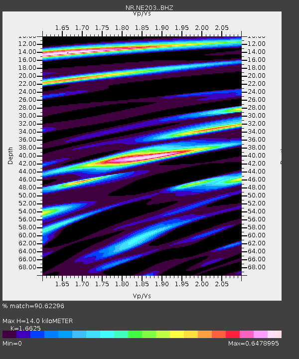
| Estimated Moho Depth: |
14.0 km |
| Estimated Crust Vp/Vs: |
1.66 |
| Assumed Crust Vp: |
6.34 km/s |
| Estimated Crust Vs: |
3.814 km/s |
| Estimated Crust Poisson's Ratio: |
0.22 |
|
| Radial Match: |
90.62296 % |
| Radial Bump: |
390 |
| Transverse Match: |
80.18378 % |
| Transverse Bump: |
400 |
| SOD ConfigId: |
13570011 |
| Insert Time: |
2019-04-29 08:38:40.309 +0000 |
| GWidth: |
2.5 |
| Max Bumps: |
400 |
| Tol: |
0.001 |
|

Signal To Noise
| Channel | StoN | STA | LTA |
| NR:NE203: :BHZ:20171201T02:42:49.931997Z | 18.107437 | 2.6470318E-6 | 1.4618479E-7 |
| NR:NE203: :BHN:20171201T02:42:49.931997Z | 5.5888004 | 8.1166604E-7 | 1.4523083E-7 |
| NR:NE203: :BHE:20171201T02:42:49.931997Z | 9.276414 | 8.9400237E-7 | 9.6373704E-8 |
| Arrivals |
| Ps | 1.5 SECOND |
| PpPs | 5.6 SECOND |
| PsPs/PpSs | 7.2 SECOND |


