You are here: Home > Network List > TA - USArray Transportable Network (new EarthScope stations) Stations List
> Station M22A Cedar Creek Ranch, Saratoga, WY, USA > Earthquake Result Viewer
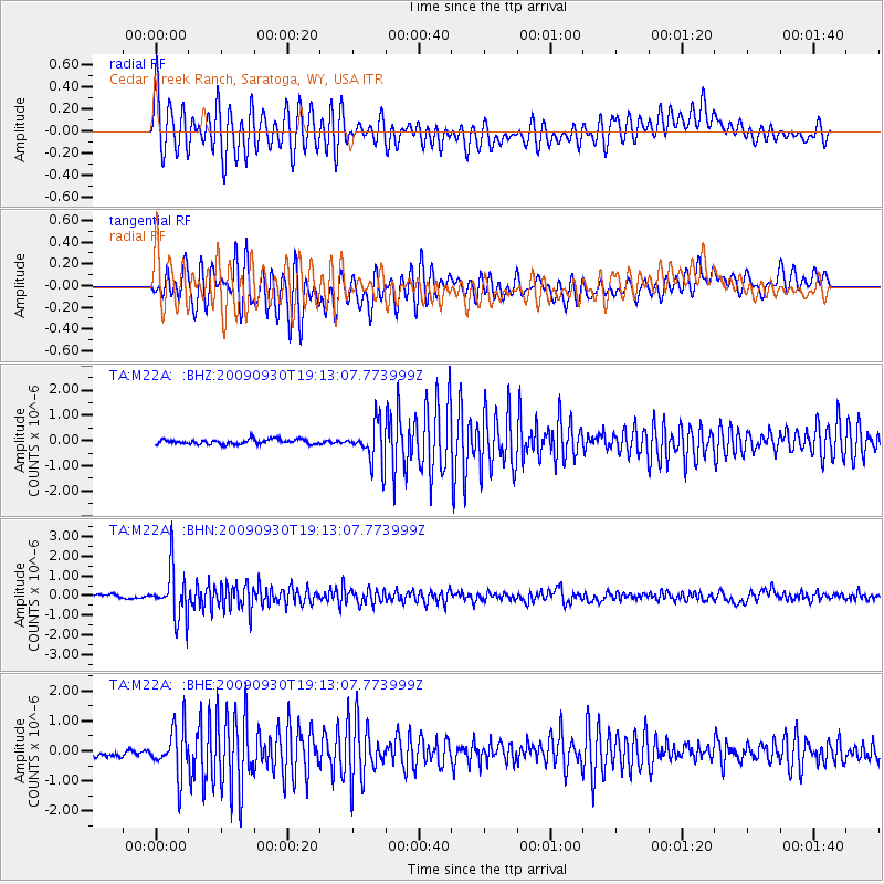
M22A Cedar Creek Ranch, Saratoga, WY, USA - Earthquake Result Viewer
*The percent match for this event was below the threshold and hence no stack was calculated.
| Earthquake location: |
Peru-Bolivia Border Region |
| Earthquake latitude/longitude: |
-15.6/-69.3 |
| Earthquake time(UTC): |
2009/09/30 (273) 19:03:17 GMT |
| Earthquake Depth: |
255 km |
| Earthquake Magnitude: |
5.9 MB, 5.8 MW |
| Earthquake Catalog/Contributor: |
WHDF/NEIC |
|
| Network: |
TA USArray Transportable Network (new EarthScope stations) |
| Station: |
M22A Cedar Creek Ranch, Saratoga, WY, USA |
| Lat/Lon: |
41.40 N/106.60 W |
| Elevation: |
2334 m |
|
| Distance: |
66.3 deg |
| Az: |
330.151 deg |
| Baz: |
140.379 deg |
| Ray Param: |
$rayparam |
*The percent match for this event was below the threshold and hence was not used in the summary stack. |
|
| Radial Match: |
75.52869 % |
| Radial Bump: |
400 |
| Transverse Match: |
82.42498 % |
| Transverse Bump: |
400 |
| SOD ConfigId: |
2622 |
| Insert Time: |
2010-03-06 07:07:32.889 +0000 |
| GWidth: |
2.5 |
| Max Bumps: |
400 |
| Tol: |
0.001 |
|
Signal To Noise
| Channel | StoN | STA | LTA |
| TA:M22A: :BHN:20090930T19:13:07.773999Z | 11.597566 | 1.254479E-6 | 1.0816744E-7 |
| TA:M22A: :BHE:20090930T19:13:07.773999Z | 4.0770125 | 7.8516973E-7 | 1.9258458E-7 |
| TA:M22A: :BHZ:20090930T19:13:07.773999Z | 8.248715 | 7.8482856E-7 | 9.514555E-8 |
| Arrivals |
| Ps | |
| PpPs | |
| PsPs/PpSs | |


