You are here: Home > Network List > TA - USArray Transportable Network (new EarthScope stations) Stations List
> Station M22A Cedar Creek Ranch, Saratoga, WY, USA > Earthquake Result Viewer
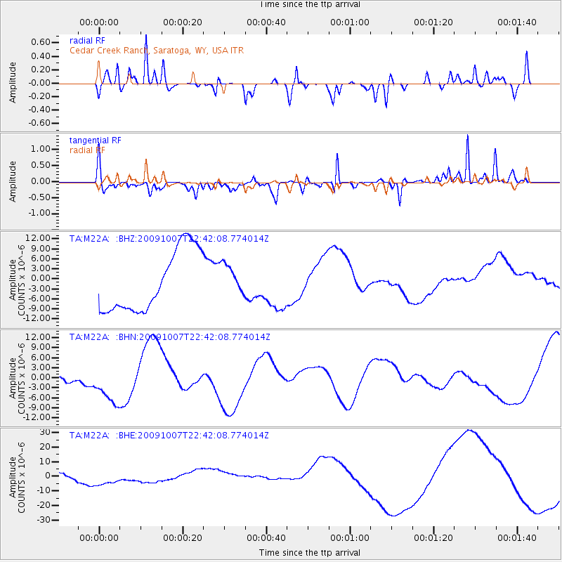
M22A Cedar Creek Ranch, Saratoga, WY, USA - Earthquake Result Viewer
*The percent match for this event was below the threshold and hence no stack was calculated.
| Earthquake location: |
Santa Cruz Islands |
| Earthquake latitude/longitude: |
-11.5/166.0 |
| Earthquake time(UTC): |
2009/10/07 (280) 22:29:18 GMT |
| Earthquake Depth: |
35 km |
| Earthquake Magnitude: |
5.5 MB |
| Earthquake Catalog/Contributor: |
WHDF/NEIC |
|
| Network: |
TA USArray Transportable Network (new EarthScope stations) |
| Station: |
M22A Cedar Creek Ranch, Saratoga, WY, USA |
| Lat/Lon: |
41.40 N/106.60 W |
| Elevation: |
2334 m |
|
| Distance: |
95.6 deg |
| Az: |
49.028 deg |
| Baz: |
259.657 deg |
| Ray Param: |
$rayparam |
*The percent match for this event was below the threshold and hence was not used in the summary stack. |
|
| Radial Match: |
67.774475 % |
| Radial Bump: |
400 |
| Transverse Match: |
72.23283 % |
| Transverse Bump: |
359 |
| SOD ConfigId: |
2622 |
| Insert Time: |
2010-03-06 07:07:37.364 +0000 |
| GWidth: |
2.5 |
| Max Bumps: |
400 |
| Tol: |
0.001 |
|
Signal To Noise
| Channel | StoN | STA | LTA |
| TA:M22A: :BHN:20091007T22:42:08.774014Z | 3.764159 | 7.2003772E-6 | 1.912878E-6 |
| TA:M22A: :BHE:20091007T22:42:08.774014Z | 4.4914036 | 6.8757818E-6 | 1.5308759E-6 |
| TA:M22A: :BHZ:20091007T22:42:08.774014Z | 0.5035779 | 4.5638894E-6 | 9.062926E-6 |
| Arrivals |
| Ps | |
| PpPs | |
| PsPs/PpSs | |


