You are here: Home > Network List > TA - USArray Transportable Network (new EarthScope stations) Stations List
> Station C24K Franklin Bluffs, AK, USA > Earthquake Result Viewer
C24K Franklin Bluffs, AK, USA - Earthquake Result Viewer
| Earthquake location: |
Northern And Central Iran |
| Earthquake latitude/longitude: |
30.7/57.3 |
| Earthquake time(UTC): |
2017/12/01 (335) 02:32:46 GMT |
| Earthquake Depth: |
9.0 km |
| Earthquake Magnitude: |
6.1 Mww |
| Earthquake Catalog/Contributor: |
NEIC PDE/us |
|
| Network: |
TA USArray Transportable Network (new EarthScope stations) |
| Station: |
C24K Franklin Bluffs, AK, USA |
| Lat/Lon: |
69.72 N/148.70 W |
| Elevation: |
115 m |
|
| Distance: |
78.1 deg |
| Az: |
8.993 deg |
| Baz: |
337.295 deg |
| Ray Param: |
0.04990391 |
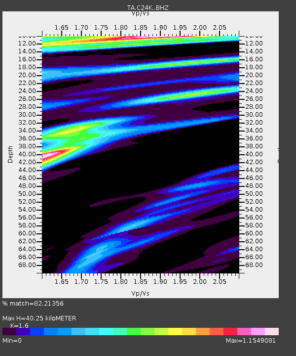
| Estimated Moho Depth: |
40.25 km |
| Estimated Crust Vp/Vs: |
1.60 |
| Assumed Crust Vp: |
6.316 km/s |
| Estimated Crust Vs: |
3.948 km/s |
| Estimated Crust Poisson's Ratio: |
0.18 |
|
| Radial Match: |
82.21356 % |
| Radial Bump: |
400 |
| Transverse Match: |
62.069145 % |
| Transverse Bump: |
354 |
| SOD ConfigId: |
13570011 |
| Insert Time: |
2019-04-29 08:39:44.093 +0000 |
| GWidth: |
2.5 |
| Max Bumps: |
400 |
| Tol: |
0.001 |
|

Signal To Noise
| Channel | StoN | STA | LTA |
| TA:C24K: :BHZ:20171201T02:44:13.575002Z | 7.0254536 | 3.579795E-6 | 5.0954645E-7 |
| TA:C24K: :BHN:20171201T02:44:13.575002Z | 2.0969527 | 1.1914294E-6 | 5.681718E-7 |
| TA:C24K: :BHE:20171201T02:44:13.575002Z | 0.79601973 | 7.8828674E-7 | 9.902855E-7 |
| Arrivals |
| Ps | 3.9 SECOND |
| PpPs | 16 SECOND |
| PsPs/PpSs | 20 SECOND |


