You are here: Home > Network List > TA - USArray Transportable Network (new EarthScope stations) Stations List
> Station F21K Alatna River, AK, USA > Earthquake Result Viewer
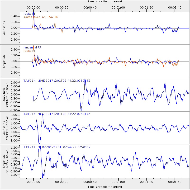
F21K Alatna River, AK, USA - Earthquake Result Viewer
*The percent match for this event was below the threshold and hence no stack was calculated.
| Earthquake location: |
Northern And Central Iran |
| Earthquake latitude/longitude: |
30.7/57.3 |
| Earthquake time(UTC): |
2017/12/01 (335) 02:32:46 GMT |
| Earthquake Depth: |
9.0 km |
| Earthquake Magnitude: |
6.1 Mww |
| Earthquake Catalog/Contributor: |
NEIC PDE/us |
|
| Network: |
TA USArray Transportable Network (new EarthScope stations) |
| Station: |
F21K Alatna River, AK, USA |
| Lat/Lon: |
67.22 N/153.48 W |
| Elevation: |
597 m |
|
| Distance: |
79.6 deg |
| Az: |
11.694 deg |
| Baz: |
333.373 deg |
| Ray Param: |
$rayparam |
*The percent match for this event was below the threshold and hence was not used in the summary stack. |
|
| Radial Match: |
69.81021 % |
| Radial Bump: |
400 |
| Transverse Match: |
76.83143 % |
| Transverse Bump: |
400 |
| SOD ConfigId: |
13570011 |
| Insert Time: |
2019-04-29 08:40:06.746 +0000 |
| GWidth: |
2.5 |
| Max Bumps: |
400 |
| Tol: |
0.001 |
|
Signal To Noise
| Channel | StoN | STA | LTA |
| TA:F21K: :BHZ:20171201T02:44:22.025015Z | 5.6498733 | 1.8365956E-6 | 3.2506847E-7 |
| TA:F21K: :BHN:20171201T02:44:22.025015Z | 1.8380537 | 6.9363637E-7 | 3.7737547E-7 |
| TA:F21K: :BHE:20171201T02:44:22.025015Z | 1.759337 | 5.1221855E-7 | 2.9114292E-7 |
| Arrivals |
| Ps | |
| PpPs | |
| PsPs/PpSs | |


