You are here: Home > Network List > TA - USArray Transportable Network (new EarthScope stations) Stations List
> Station G31M Satah River, YT, CAN > Earthquake Result Viewer
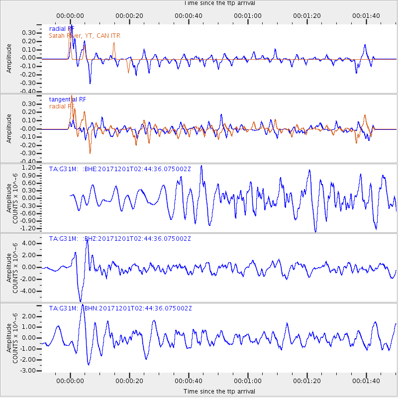
G31M Satah River, YT, CAN - Earthquake Result Viewer
*The percent match for this event was below the threshold and hence no stack was calculated.
| Earthquake location: |
Northern And Central Iran |
| Earthquake latitude/longitude: |
30.7/57.3 |
| Earthquake time(UTC): |
2017/12/01 (335) 02:32:46 GMT |
| Earthquake Depth: |
9.0 km |
| Earthquake Magnitude: |
6.1 Mww |
| Earthquake Catalog/Contributor: |
NEIC PDE/us |
|
| Network: |
TA USArray Transportable Network (new EarthScope stations) |
| Station: |
G31M Satah River, YT, CAN |
| Lat/Lon: |
66.92 N/134.27 W |
| Elevation: |
61 m |
|
| Distance: |
82.2 deg |
| Az: |
4.582 deg |
| Baz: |
349.951 deg |
| Ray Param: |
$rayparam |
*The percent match for this event was below the threshold and hence was not used in the summary stack. |
|
| Radial Match: |
74.00051 % |
| Radial Bump: |
305 |
| Transverse Match: |
74.47965 % |
| Transverse Bump: |
400 |
| SOD ConfigId: |
13570011 |
| Insert Time: |
2019-04-29 08:40:22.114 +0000 |
| GWidth: |
2.5 |
| Max Bumps: |
400 |
| Tol: |
0.001 |
|
Signal To Noise
| Channel | StoN | STA | LTA |
| TA:G31M: :BHZ:20171201T02:44:36.075002Z | 8.589396 | 2.7381066E-6 | 3.1877752E-7 |
| TA:G31M: :BHN:20171201T02:44:36.075002Z | 2.6885364 | 1.519368E-6 | 5.6512823E-7 |
| TA:G31M: :BHE:20171201T02:44:36.075002Z | 1.8198279 | 4.6741116E-7 | 2.568436E-7 |
| Arrivals |
| Ps | |
| PpPs | |
| PsPs/PpSs | |


