You are here: Home > Network List > G - GEOSCOPE Stations List
> Station SANVU Espiritu Santo, Vanuatu > Earthquake Result Viewer
SANVU Espiritu Santo, Vanuatu - Earthquake Result Viewer
| Earthquake location: |
Myanmar-India Border Region |
| Earthquake latitude/longitude: |
23.1/94.9 |
| Earthquake time(UTC): |
2016/04/13 (104) 13:55:17 GMT |
| Earthquake Depth: |
135 km |
| Earthquake Magnitude: |
6.9 MWB |
| Earthquake Catalog/Contributor: |
NEIC PDE/NEIC COMCAT |
|
| Network: |
G GEOSCOPE |
| Station: |
SANVU Espiritu Santo, Vanuatu |
| Lat/Lon: |
15.45 S/167.20 E |
| Elevation: |
56 m |
|
| Distance: |
80.4 deg |
| Az: |
111.299 deg |
| Baz: |
297.203 deg |
| Ray Param: |
0.047979042 |
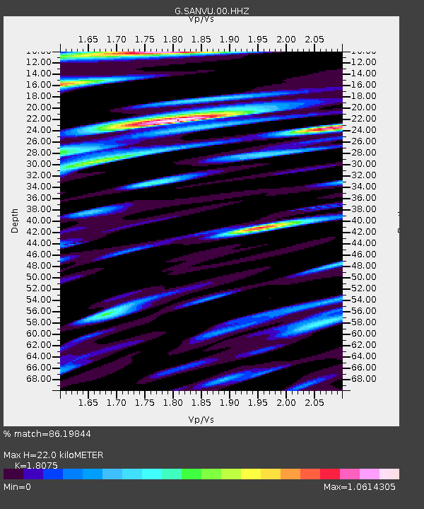
| Estimated Moho Depth: |
22.0 km |
| Estimated Crust Vp/Vs: |
1.81 |
| Assumed Crust Vp: |
4.802 km/s |
| Estimated Crust Vs: |
2.657 km/s |
| Estimated Crust Poisson's Ratio: |
0.28 |
|
| Radial Match: |
86.19844 % |
| Radial Bump: |
400 |
| Transverse Match: |
90.96622 % |
| Transverse Bump: |
400 |
| SOD ConfigId: |
1475611 |
| Insert Time: |
2016-04-27 14:02:42.957 +0000 |
| GWidth: |
2.5 |
| Max Bumps: |
400 |
| Tol: |
0.001 |
|

Signal To Noise
| Channel | StoN | STA | LTA |
| G:SANVU:00:HHZ:20160413T14:06:43.429998Z | 60.336903 | 1.6093016E-5 | 2.6671927E-7 |
| G:SANVU:00:HHN:20160413T14:06:43.429998Z | 11.952089 | 3.3379624E-6 | 2.7927857E-7 |
| G:SANVU:00:HHE:20160413T14:06:43.429998Z | 8.442429 | 3.5376465E-6 | 4.1903184E-7 |
| Arrivals |
| Ps | 3.8 SECOND |
| PpPs | 13 SECOND |
| PsPs/PpSs | 16 SECOND |


