You are here: Home > Network List > TA - USArray Transportable Network (new EarthScope stations) Stations List
> Station I17K Unalakleet, AK, USA > Earthquake Result Viewer
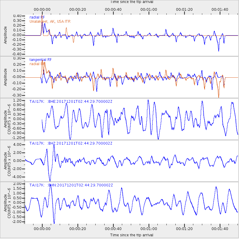
I17K Unalakleet, AK, USA - Earthquake Result Viewer
*The percent match for this event was below the threshold and hence no stack was calculated.
| Earthquake location: |
Northern And Central Iran |
| Earthquake latitude/longitude: |
30.7/57.3 |
| Earthquake time(UTC): |
2017/12/01 (335) 02:32:46 GMT |
| Earthquake Depth: |
9.0 km |
| Earthquake Magnitude: |
6.1 Mww |
| Earthquake Catalog/Contributor: |
NEIC PDE/us |
|
| Network: |
TA USArray Transportable Network (new EarthScope stations) |
| Station: |
I17K Unalakleet, AK, USA |
| Lat/Lon: |
63.89 N/160.70 W |
| Elevation: |
105 m |
|
| Distance: |
81.0 deg |
| Az: |
16.015 deg |
| Baz: |
327.538 deg |
| Ray Param: |
$rayparam |
*The percent match for this event was below the threshold and hence was not used in the summary stack. |
|
| Radial Match: |
76.801544 % |
| Radial Bump: |
340 |
| Transverse Match: |
61.14883 % |
| Transverse Bump: |
345 |
| SOD ConfigId: |
13570011 |
| Insert Time: |
2019-04-29 08:40:33.473 +0000 |
| GWidth: |
2.5 |
| Max Bumps: |
400 |
| Tol: |
0.001 |
|
Signal To Noise
| Channel | StoN | STA | LTA |
| TA:I17K: :BHZ:20171201T02:44:29.700002Z | 5.8085537 | 2.3061232E-6 | 3.9702192E-7 |
| TA:I17K: :BHN:20171201T02:44:29.700002Z | 2.1947763 | 9.747229E-7 | 4.4411038E-7 |
| TA:I17K: :BHE:20171201T02:44:29.700002Z | 0.9188578 | 4.862401E-7 | 5.291788E-7 |
| Arrivals |
| Ps | |
| PpPs | |
| PsPs/PpSs | |


