You are here: Home > Network List > TA - USArray Transportable Network (new EarthScope stations) Stations List
> Station I28M Miner Creek, YT, CAN > Earthquake Result Viewer
I28M Miner Creek, YT, CAN - Earthquake Result Viewer
| Earthquake location: |
Northern And Central Iran |
| Earthquake latitude/longitude: |
30.7/57.3 |
| Earthquake time(UTC): |
2017/12/01 (335) 02:32:46 GMT |
| Earthquake Depth: |
9.0 km |
| Earthquake Magnitude: |
6.1 Mww |
| Earthquake Catalog/Contributor: |
NEIC PDE/us |
|
| Network: |
TA USArray Transportable Network (new EarthScope stations) |
| Station: |
I28M Miner Creek, YT, CAN |
| Lat/Lon: |
65.45 N/139.94 W |
| Elevation: |
1188 m |
|
| Distance: |
83.2 deg |
| Az: |
7.168 deg |
| Baz: |
345.101 deg |
| Ray Param: |
0.046366137 |
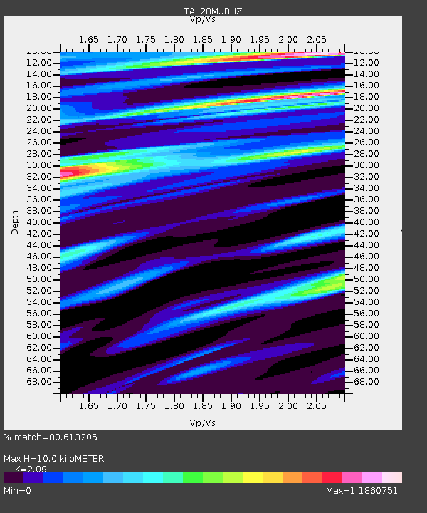
| Estimated Moho Depth: |
10.0 km |
| Estimated Crust Vp/Vs: |
2.09 |
| Assumed Crust Vp: |
6.566 km/s |
| Estimated Crust Vs: |
3.142 km/s |
| Estimated Crust Poisson's Ratio: |
0.35 |
|
| Radial Match: |
80.613205 % |
| Radial Bump: |
400 |
| Transverse Match: |
60.437256 % |
| Transverse Bump: |
351 |
| SOD ConfigId: |
13570011 |
| Insert Time: |
2019-04-29 08:40:37.877 +0000 |
| GWidth: |
2.5 |
| Max Bumps: |
400 |
| Tol: |
0.001 |
|

Signal To Noise
| Channel | StoN | STA | LTA |
| TA:I28M: :BHZ:20171201T02:44:40.99999Z | 3.974611 | 2.3286286E-6 | 5.8587585E-7 |
| TA:I28M: :BHN:20171201T02:44:40.99999Z | 1.4734744 | 8.497447E-7 | 5.7669456E-7 |
| TA:I28M: :BHE:20171201T02:44:40.99999Z | 0.91713697 | 3.8084875E-7 | 4.152583E-7 |
| Arrivals |
| Ps | 1.7 SECOND |
| PpPs | 4.6 SECOND |
| PsPs/PpSs | 6.3 SECOND |


