You are here: Home > Network List > TA - USArray Transportable Network (new EarthScope stations) Stations List
> Station I30M Mount Dempster, Yukon, CAN > Earthquake Result Viewer
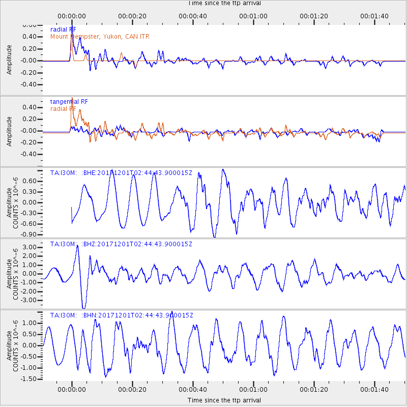
I30M Mount Dempster, Yukon, CAN - Earthquake Result Viewer
*The percent match for this event was below the threshold and hence no stack was calculated.
| Earthquake location: |
Northern And Central Iran |
| Earthquake latitude/longitude: |
30.7/57.3 |
| Earthquake time(UTC): |
2017/12/01 (335) 02:32:46 GMT |
| Earthquake Depth: |
9.0 km |
| Earthquake Magnitude: |
6.1 Mww |
| Earthquake Catalog/Contributor: |
NEIC PDE/us |
|
| Network: |
TA USArray Transportable Network (new EarthScope stations) |
| Station: |
I30M Mount Dempster, Yukon, CAN |
| Lat/Lon: |
65.22 N/136.38 W |
| Elevation: |
1399 m |
|
| Distance: |
83.8 deg |
| Az: |
5.758 deg |
| Baz: |
348.171 deg |
| Ray Param: |
$rayparam |
*The percent match for this event was below the threshold and hence was not used in the summary stack. |
|
| Radial Match: |
67.452 % |
| Radial Bump: |
400 |
| Transverse Match: |
65.18103 % |
| Transverse Bump: |
400 |
| SOD ConfigId: |
13570011 |
| Insert Time: |
2019-04-29 08:40:40.524 +0000 |
| GWidth: |
2.5 |
| Max Bumps: |
400 |
| Tol: |
0.001 |
|
Signal To Noise
| Channel | StoN | STA | LTA |
| TA:I30M: :BHZ:20171201T02:44:43.900015Z | 8.344359 | 2.3632015E-6 | 2.8320946E-7 |
| TA:I30M: :BHN:20171201T02:44:43.900015Z | 1.4406426 | 6.451116E-7 | 4.4779432E-7 |
| TA:I30M: :BHE:20171201T02:44:43.900015Z | 0.6675066 | 3.1459652E-7 | 4.71301E-7 |
| Arrivals |
| Ps | |
| PpPs | |
| PsPs/PpSs | |


