You are here: Home > Network List > TA - USArray Transportable Network (new EarthScope stations) Stations List
> Station M31M Drury Creek, Yukon, CA > Earthquake Result Viewer
M31M Drury Creek, Yukon, CA - Earthquake Result Viewer
| Earthquake location: |
Northern And Central Iran |
| Earthquake latitude/longitude: |
30.7/57.3 |
| Earthquake time(UTC): |
2017/12/01 (335) 02:32:46 GMT |
| Earthquake Depth: |
9.0 km |
| Earthquake Magnitude: |
6.1 Mww |
| Earthquake Catalog/Contributor: |
NEIC PDE/us |
|
| Network: |
TA USArray Transportable Network (new EarthScope stations) |
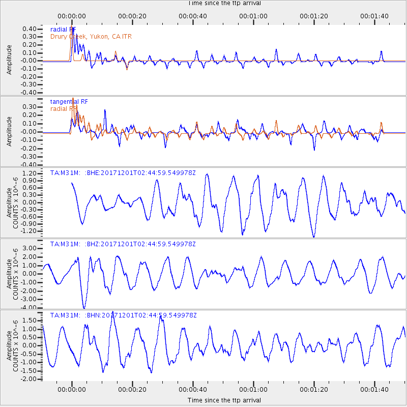
| Station: |
M31M Drury Creek, Yukon, CA |
| Lat/Lon: |
62.20 N/134.39 W |
| Elevation: |
639 m |
|
| Distance: |
86.9 deg |
| Az: |
5.465 deg |
| Baz: |
349.926 deg |
| Ray Param: |
0.04371564 |
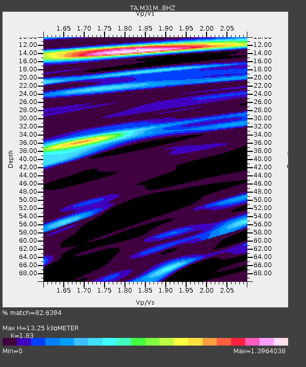
| Estimated Moho Depth: |
13.25 km |
| Estimated Crust Vp/Vs: |
1.83 |
| Assumed Crust Vp: |
6.419 km/s |
| Estimated Crust Vs: |
3.508 km/s |
| Estimated Crust Poisson's Ratio: |
0.29 |
|
| Radial Match: |
82.6394 % |
| Radial Bump: |
400 |
| Transverse Match: |
77.025604 % |
| Transverse Bump: |
400 |
| SOD ConfigId: |
13570011 |
| Insert Time: |
2019-04-29 08:41:10.640 +0000 |
| GWidth: |
2.5 |
| Max Bumps: |
400 |
| Tol: |
0.001 |
|
Signal To Noise
| Channel | StoN | STA | LTA |
| TA:M31M: :BHZ:20171201T02:44:59.549978Z | 2.2281764 | 2.1327444E-6 | 9.571704E-7 |
| TA:M31M: :BHN:20171201T02:44:59.549978Z | 0.9154637 | 7.5261823E-7 | 8.22117E-7 |
| TA:M31M: :BHE:20171201T02:44:59.549978Z | 1.1699562 | 3.784556E-7 | 3.2347845E-7 |
| Arrivals |
| Ps | 1.8 SECOND |
| PpPs | 5.7 SECOND |
| PsPs/PpSs | 7.5 SECOND |


