You are here: Home > Network List > II - Global Seismograph Network (GSN - IRIS/IDA) Stations List
> Station WRAB Tennant Creek, NT, Australia > Earthquake Result Viewer
WRAB Tennant Creek, NT, Australia - Earthquake Result Viewer
| Earthquake location: |
Myanmar-India Border Region |
| Earthquake latitude/longitude: |
23.1/94.9 |
| Earthquake time(UTC): |
2016/04/13 (104) 13:55:17 GMT |
| Earthquake Depth: |
135 km |
| Earthquake Magnitude: |
6.9 MWB |
| Earthquake Catalog/Contributor: |
NEIC PDE/NEIC COMCAT |
|
| Network: |
II Global Seismograph Network (GSN - IRIS/IDA) |
| Station: |
WRAB Tennant Creek, NT, Australia |
| Lat/Lon: |
19.93 S/134.36 E |
| Elevation: |
366 m |
|
| Distance: |
57.6 deg |
| Az: |
134.894 deg |
| Baz: |
316.12 deg |
| Ray Param: |
0.06299191 |
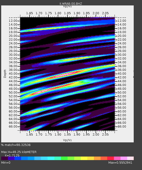
| Estimated Moho Depth: |
49.25 km |
| Estimated Crust Vp/Vs: |
1.71 |
| Assumed Crust Vp: |
6.642 km/s |
| Estimated Crust Vs: |
3.879 km/s |
| Estimated Crust Poisson's Ratio: |
0.24 |
|
| Radial Match: |
98.32536 % |
| Radial Bump: |
362 |
| Transverse Match: |
92.62981 % |
| Transverse Bump: |
400 |
| SOD ConfigId: |
1475611 |
| Insert Time: |
2016-04-27 14:07:52.979 +0000 |
| GWidth: |
2.5 |
| Max Bumps: |
400 |
| Tol: |
0.001 |
|
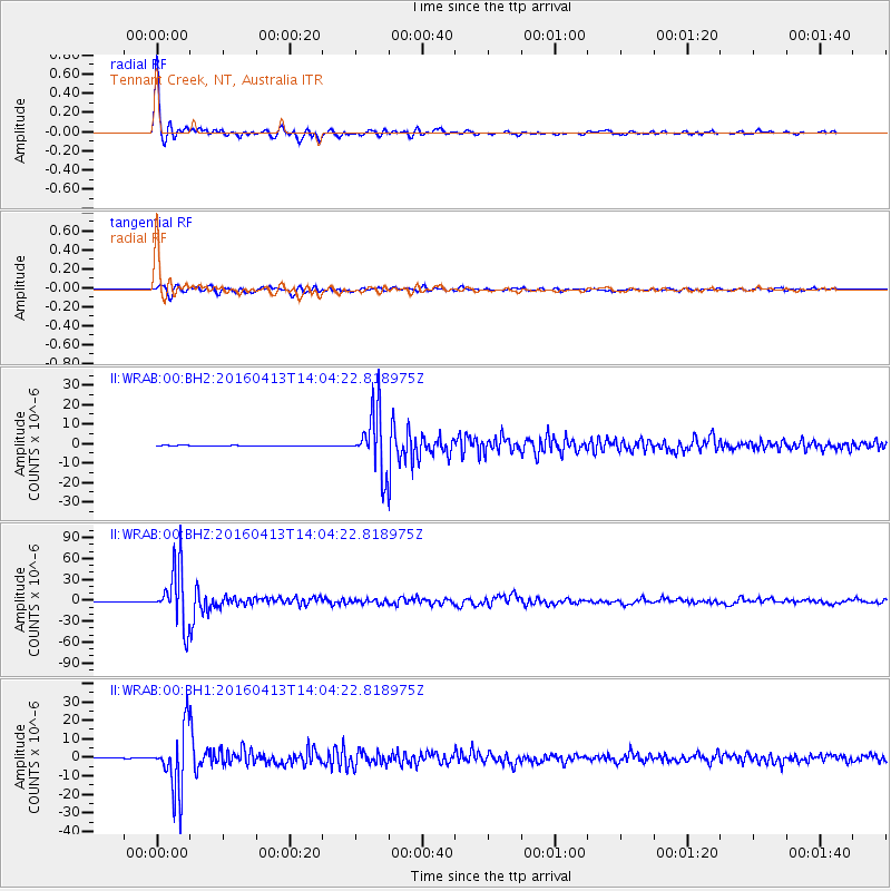
Signal To Noise
| Channel | StoN | STA | LTA |
| II:WRAB:00:BHZ:20160413T14:04:22.818975Z | 293.25864 | 4.075161E-5 | 1.3896134E-7 |
| II:WRAB:00:BH1:20160413T14:04:22.818975Z | 130.01073 | 1.6554068E-5 | 1.2732848E-7 |
| II:WRAB:00:BH2:20160413T14:04:22.818975Z | 206.90623 | 1.539829E-5 | 7.442158E-8 |
| Arrivals |
| Ps | 5.6 SECOND |
| PpPs | 19 SECOND |
| PsPs/PpSs | 25 SECOND |


