You are here: Home > Network List > TA - USArray Transportable Network (new EarthScope stations) Stations List
> Station P17K Kvichak River, AK, USA > Earthquake Result Viewer
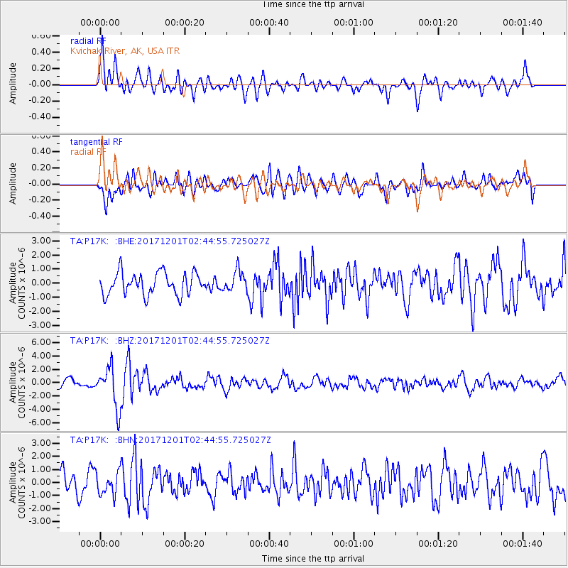
P17K Kvichak River, AK, USA - Earthquake Result Viewer
*The percent match for this event was below the threshold and hence no stack was calculated.
| Earthquake location: |
Northern And Central Iran |
| Earthquake latitude/longitude: |
30.7/57.3 |
| Earthquake time(UTC): |
2017/12/01 (335) 02:32:46 GMT |
| Earthquake Depth: |
9.0 km |
| Earthquake Magnitude: |
6.1 Mww |
| Earthquake Catalog/Contributor: |
NEIC PDE/us |
|
| Network: |
TA USArray Transportable Network (new EarthScope stations) |
| Station: |
P17K Kvichak River, AK, USA |
| Lat/Lon: |
59.20 N/156.44 W |
| Elevation: |
91 m |
|
| Distance: |
86.1 deg |
| Az: |
16.655 deg |
| Baz: |
331.349 deg |
| Ray Param: |
$rayparam |
*The percent match for this event was below the threshold and hence was not used in the summary stack. |
|
| Radial Match: |
73.34043 % |
| Radial Bump: |
400 |
| Transverse Match: |
66.31126 % |
| Transverse Bump: |
400 |
| SOD ConfigId: |
13570011 |
| Insert Time: |
2019-04-29 08:41:26.027 +0000 |
| GWidth: |
2.5 |
| Max Bumps: |
400 |
| Tol: |
0.001 |
|
Signal To Noise
| Channel | StoN | STA | LTA |
| TA:P17K: :BHZ:20171201T02:44:55.725027Z | 6.783655 | 3.1513578E-6 | 4.645516E-7 |
| TA:P17K: :BHN:20171201T02:44:55.725027Z | 1.2522497 | 8.4815616E-7 | 6.7730593E-7 |
| TA:P17K: :BHE:20171201T02:44:55.725027Z | 0.9392887 | 7.4089985E-7 | 7.887882E-7 |
| Arrivals |
| Ps | |
| PpPs | |
| PsPs/PpSs | |


