You are here: Home > Network List > TA - USArray Transportable Network (new EarthScope stations) Stations List
> Station A22K Sinclair Lake, AK, USA > Earthquake Result Viewer
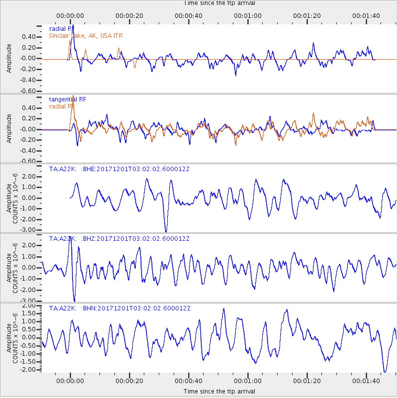
A22K Sinclair Lake, AK, USA - Earthquake Result Viewer
*The percent match for this event was below the threshold and hence no stack was calculated.
| Earthquake location: |
Eastern New Guinea Reg., P.N.G. |
| Earthquake latitude/longitude: |
-6.1/147.6 |
| Earthquake time(UTC): |
2017/12/01 (335) 02:49:59 GMT |
| Earthquake Depth: |
40 km |
| Earthquake Magnitude: |
6.0 Mww |
| Earthquake Catalog/Contributor: |
NEIC PDE/us |
|
| Network: |
TA USArray Transportable Network (new EarthScope stations) |
| Station: |
A22K Sinclair Lake, AK, USA |
| Lat/Lon: |
71.00 N/154.97 W |
| Elevation: |
6.0 m |
|
| Distance: |
85.7 deg |
| Az: |
16.061 deg |
| Baz: |
237.15 deg |
| Ray Param: |
$rayparam |
*The percent match for this event was below the threshold and hence was not used in the summary stack. |
|
| Radial Match: |
68.62338 % |
| Radial Bump: |
387 |
| Transverse Match: |
52.2956 % |
| Transverse Bump: |
378 |
| SOD ConfigId: |
13570011 |
| Insert Time: |
2019-04-29 08:45:02.489 +0000 |
| GWidth: |
2.5 |
| Max Bumps: |
400 |
| Tol: |
0.001 |
|
Signal To Noise
| Channel | StoN | STA | LTA |
| TA:A22K: :BHZ:20171201T03:02:02.600012Z | 4.489225 | 1.6762111E-6 | 3.733854E-7 |
| TA:A22K: :BHN:20171201T03:02:02.600012Z | 0.9000956 | 6.3098514E-7 | 7.0102016E-7 |
| TA:A22K: :BHE:20171201T03:02:02.600012Z | 2.2064958 | 1.4493519E-6 | 6.5685686E-7 |
| Arrivals |
| Ps | |
| PpPs | |
| PsPs/PpSs | |


