You are here: Home > Network List > TA - USArray Transportable Network (new EarthScope stations) Stations List
> Station C16K Lisburne Hills, AK, USA > Earthquake Result Viewer
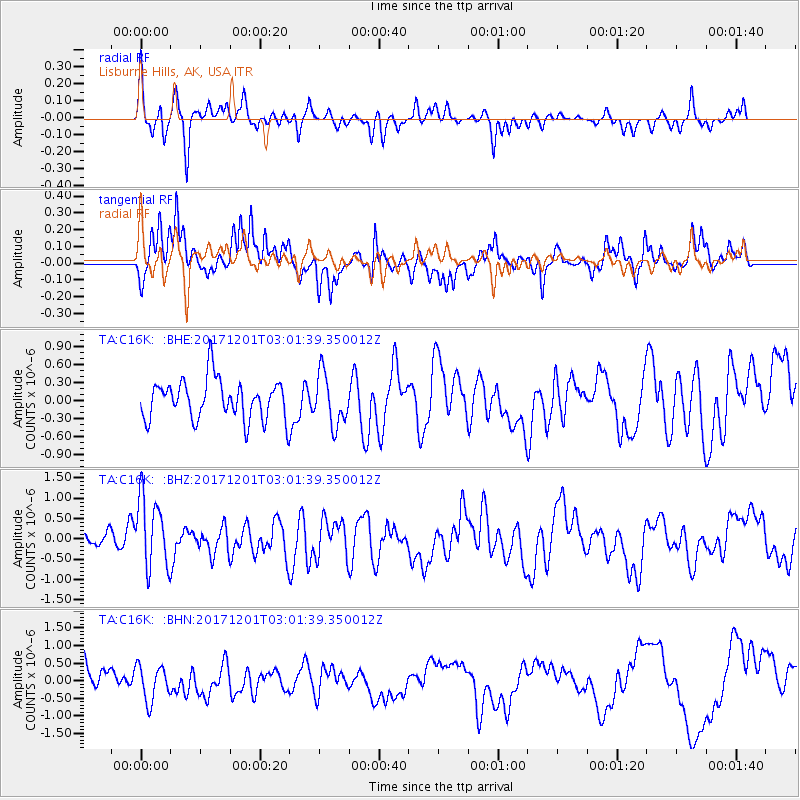
C16K Lisburne Hills, AK, USA - Earthquake Result Viewer
*The percent match for this event was below the threshold and hence no stack was calculated.
| Earthquake location: |
Eastern New Guinea Reg., P.N.G. |
| Earthquake latitude/longitude: |
-6.1/147.6 |
| Earthquake time(UTC): |
2017/12/01 (335) 02:49:59 GMT |
| Earthquake Depth: |
40 km |
| Earthquake Magnitude: |
6.0 Mww |
| Earthquake Catalog/Contributor: |
NEIC PDE/us |
|
| Network: |
TA USArray Transportable Network (new EarthScope stations) |
| Station: |
C16K Lisburne Hills, AK, USA |
| Lat/Lon: |
68.27 N/165.34 W |
| Elevation: |
102 m |
|
| Distance: |
81.1 deg |
| Az: |
16.004 deg |
| Baz: |
227.424 deg |
| Ray Param: |
$rayparam |
*The percent match for this event was below the threshold and hence was not used in the summary stack. |
|
| Radial Match: |
59.91053 % |
| Radial Bump: |
289 |
| Transverse Match: |
59.06907 % |
| Transverse Bump: |
396 |
| SOD ConfigId: |
13570011 |
| Insert Time: |
2019-04-29 08:45:04.358 +0000 |
| GWidth: |
2.5 |
| Max Bumps: |
400 |
| Tol: |
0.001 |
|
Signal To Noise
| Channel | StoN | STA | LTA |
| TA:C16K: :BHZ:20171201T03:01:39.350012Z | 1.9160792 | 8.793287E-7 | 4.5892085E-7 |
| TA:C16K: :BHN:20171201T03:01:39.350012Z | 1.2947567 | 4.9653806E-7 | 3.8349913E-7 |
| TA:C16K: :BHE:20171201T03:01:39.350012Z | 1.2789031 | 4.27145E-7 | 3.3399326E-7 |
| Arrivals |
| Ps | |
| PpPs | |
| PsPs/PpSs | |


