You are here: Home > Network List > TA - USArray Transportable Network (new EarthScope stations) Stations List
> Station G16K Koyuk River, AK, USA > Earthquake Result Viewer
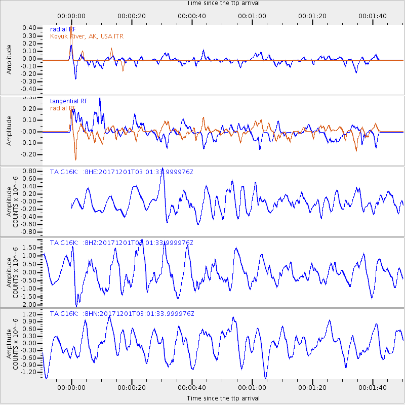
G16K Koyuk River, AK, USA - Earthquake Result Viewer
*The percent match for this event was below the threshold and hence no stack was calculated.
| Earthquake location: |
Eastern New Guinea Reg., P.N.G. |
| Earthquake latitude/longitude: |
-6.1/147.6 |
| Earthquake time(UTC): |
2017/12/01 (335) 02:49:59 GMT |
| Earthquake Depth: |
40 km |
| Earthquake Magnitude: |
6.0 Mww |
| Earthquake Catalog/Contributor: |
NEIC PDE/us |
|
| Network: |
TA USArray Transportable Network (new EarthScope stations) |
| Station: |
G16K Koyuk River, AK, USA |
| Lat/Lon: |
65.39 N/162.35 W |
| Elevation: |
169 m |
|
| Distance: |
80.1 deg |
| Az: |
19.004 deg |
| Baz: |
230.659 deg |
| Ray Param: |
$rayparam |
*The percent match for this event was below the threshold and hence was not used in the summary stack. |
|
| Radial Match: |
69.45235 % |
| Radial Bump: |
400 |
| Transverse Match: |
80.40698 % |
| Transverse Bump: |
400 |
| SOD ConfigId: |
13570011 |
| Insert Time: |
2019-04-29 08:45:20.726 +0000 |
| GWidth: |
2.5 |
| Max Bumps: |
400 |
| Tol: |
0.001 |
|
Signal To Noise
| Channel | StoN | STA | LTA |
| TA:G16K: :BHZ:20171201T03:01:33.999976Z | 2.2135105 | 1.194931E-6 | 5.3983524E-7 |
| TA:G16K: :BHN:20171201T03:01:33.999976Z | 1.0349711 | 5.0911615E-7 | 4.919134E-7 |
| TA:G16K: :BHE:20171201T03:01:33.999976Z | 2.1298964 | 4.6054708E-7 | 2.1622982E-7 |
| Arrivals |
| Ps | |
| PpPs | |
| PsPs/PpSs | |


