You are here: Home > Network List > IU - Global Seismograph Network (GSN - IRIS/USGS) Stations List
> Station LSZ Lusaka, Zambia > Earthquake Result Viewer
LSZ Lusaka, Zambia - Earthquake Result Viewer

| Earthquake location: |
Myanmar-India Border Region |
| Earthquake latitude/longitude: |
23.1/94.9 |
| Earthquake time(UTC): |
2016/04/13 (104) 13:55:17 GMT |
| Earthquake Depth: |
135 km |
| Earthquake Magnitude: |
6.9 MWB |
| Earthquake Catalog/Contributor: |
NEIC PDE/NEIC COMCAT |
|
| Network: |
IU Global Seismograph Network (GSN - IRIS/USGS) |
| Station: |
LSZ Lusaka, Zambia |
| Lat/Lon: |
15.28 S/28.19 E |
| Elevation: |
1200 m |
|
| Distance: |
75.6 deg |
| Az: |
246.247 deg |
| Baz: |
60.813 deg |
| Ray Param: |
0.051236004 |
| Estimated Moho Depth: |
45.5 km |
| Estimated Crust Vp/Vs: |
1.62 |
| Assumed Crust Vp: |
6.642 km/s |
| Estimated Crust Vs: |
4.094 km/s |
| Estimated Crust Poisson's Ratio: |
0.19 |
|
| Radial Match: |
96.62594 % |
| Radial Bump: |
400 |
| Transverse Match: |
90.36773 % |
| Transverse Bump: |
400 |
| SOD ConfigId: |
1475611 |
| Insert Time: |
2016-04-27 14:11:33.409 +0000 |
| GWidth: |
2.5 |
| Max Bumps: |
400 |
| Tol: |
0.001 |
|
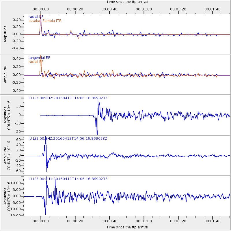
Signal To Noise
| Channel | StoN | STA | LTA |
| IU:LSZ:00:BHZ:20160413T14:06:16.869023Z | 184.49187 | 2.8534812E-5 | 1.5466705E-7 |
| IU:LSZ:00:BH1:20160413T14:06:16.869023Z | 56.970676 | 5.5221954E-6 | 9.6930485E-8 |
| IU:LSZ:00:BH2:20160413T14:06:16.869023Z | 103.34986 | 8.909598E-6 | 8.620813E-8 |
| Arrivals |
| Ps | 4.4 SECOND |
| PpPs | 17 SECOND |
| PsPs/PpSs | 22 SECOND |


