You are here: Home > Network List > TA - USArray Transportable Network (new EarthScope stations) Stations List
> Station R33M Jennings River, BC, CAN > Earthquake Result Viewer
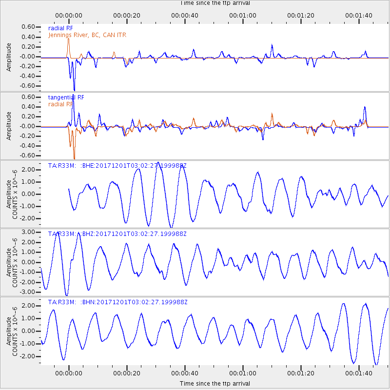
R33M Jennings River, BC, CAN - Earthquake Result Viewer
*The percent match for this event was below the threshold and hence no stack was calculated.
| Earthquake location: |
Eastern New Guinea Reg., P.N.G. |
| Earthquake latitude/longitude: |
-6.1/147.6 |
| Earthquake time(UTC): |
2017/12/01 (335) 02:49:59 GMT |
| Earthquake Depth: |
40 km |
| Earthquake Magnitude: |
6.0 Mww |
| Earthquake Catalog/Contributor: |
NEIC PDE/us |
|
| Network: |
TA USArray Transportable Network (new EarthScope stations) |
| Station: |
R33M Jennings River, BC, CAN |
| Lat/Lon: |
59.39 N/130.97 W |
| Elevation: |
1437 m |
|
| Distance: |
90.9 deg |
| Az: |
30.395 deg |
| Baz: |
259.523 deg |
| Ray Param: |
$rayparam |
*The percent match for this event was below the threshold and hence was not used in the summary stack. |
|
| Radial Match: |
72.08159 % |
| Radial Bump: |
358 |
| Transverse Match: |
76.066795 % |
| Transverse Bump: |
373 |
| SOD ConfigId: |
13570011 |
| Insert Time: |
2019-04-29 08:45:59.645 +0000 |
| GWidth: |
2.5 |
| Max Bumps: |
400 |
| Tol: |
0.001 |
|
Signal To Noise
| Channel | StoN | STA | LTA |
| TA:R33M: :BHZ:20171201T03:02:27.199988Z | 1.803844 | 2.1226267E-6 | 1.1767241E-6 |
| TA:R33M: :BHN:20171201T03:02:27.199988Z | 0.7137224 | 8.7533675E-7 | 1.2264386E-6 |
| TA:R33M: :BHE:20171201T03:02:27.199988Z | 1.5946387 | 1.7216269E-6 | 1.0796344E-6 |
| Arrivals |
| Ps | |
| PpPs | |
| PsPs/PpSs | |


