You are here: Home > Network List > IU - Global Seismograph Network (GSN - IRIS/USGS) Stations List
> Station NWAO Narrogin, Australia > Earthquake Result Viewer
NWAO Narrogin, Australia - Earthquake Result Viewer
| Earthquake location: |
Myanmar-India Border Region |
| Earthquake latitude/longitude: |
23.1/94.9 |
| Earthquake time(UTC): |
2016/04/13 (104) 13:55:17 GMT |
| Earthquake Depth: |
135 km |
| Earthquake Magnitude: |
6.9 MWB |
| Earthquake Catalog/Contributor: |
NEIC PDE/NEIC COMCAT |
|
| Network: |
IU Global Seismograph Network (GSN - IRIS/USGS) |
| Station: |
NWAO Narrogin, Australia |
| Lat/Lon: |
32.93 S/117.24 E |
| Elevation: |
380 m |
|
| Distance: |
59.7 deg |
| Az: |
158.266 deg |
| Baz: |
336.089 deg |
| Ray Param: |
0.061618213 |
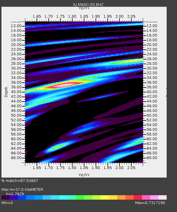
| Estimated Moho Depth: |
37.0 km |
| Estimated Crust Vp/Vs: |
1.76 |
| Assumed Crust Vp: |
6.419 km/s |
| Estimated Crust Vs: |
3.642 km/s |
| Estimated Crust Poisson's Ratio: |
0.26 |
|
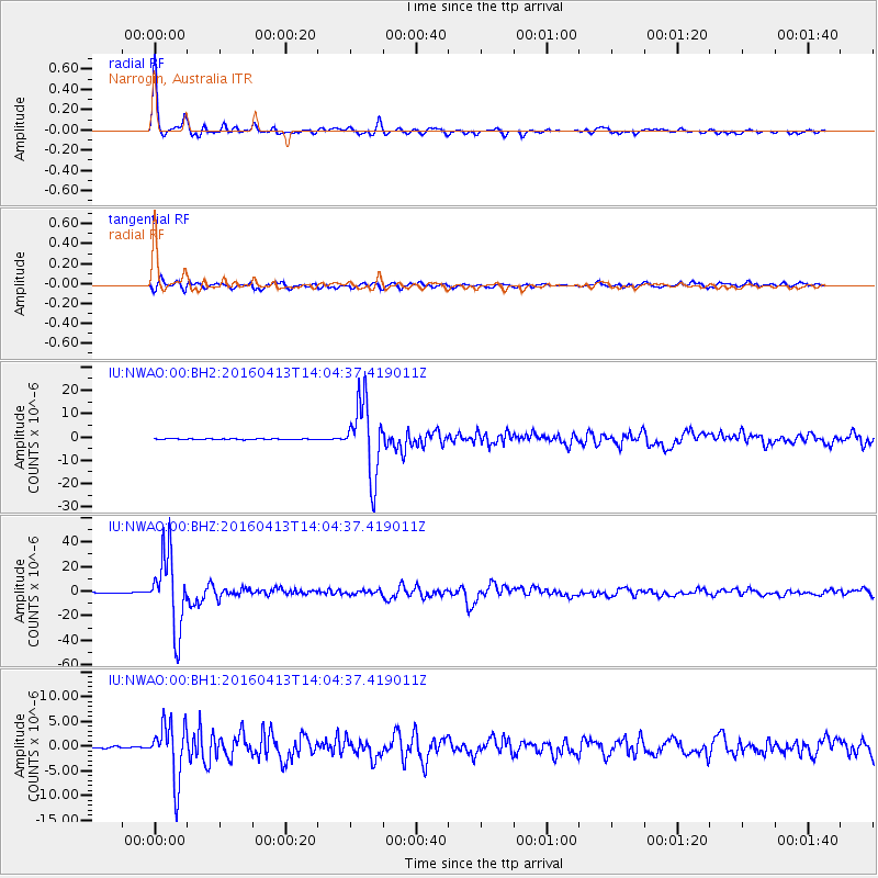
| Radial Match: |
97.53687 % |
| Radial Bump: |
344 |
| Transverse Match: |
81.53895 % |
| Transverse Bump: |
400 |
| SOD ConfigId: |
1475611 |
| Insert Time: |
2016-04-27 14:11:50.919 +0000 |
| GWidth: |
2.5 |
| Max Bumps: |
400 |
| Tol: |
0.001 |
|
Signal To Noise
| Channel | StoN | STA | LTA |
| IU:NWAO:00:BHZ:20160413T14:04:37.419011Z | 115.0755 | 2.9743253E-5 | 2.5846728E-7 |
| IU:NWAO:00:BH1:20160413T14:04:37.419011Z | 38.477936 | 5.7347092E-6 | 1.490389E-7 |
| IU:NWAO:00:BH2:20160413T14:04:37.419011Z | 97.5132 | 1.5345315E-5 | 1.5736654E-7 |
| Arrivals |
| Ps | 4.6 SECOND |
| PpPs | 15 SECOND |
| PsPs/PpSs | 20 SECOND |


