You are here: Home > Network List > IU - Global Seismograph Network (GSN - IRIS/USGS) Stations List
> Station PAB San Pablo, Spain > Earthquake Result Viewer
PAB San Pablo, Spain - Earthquake Result Viewer
| Earthquake location: |
Myanmar-India Border Region |
| Earthquake latitude/longitude: |
23.1/94.9 |
| Earthquake time(UTC): |
2016/04/13 (104) 13:55:17 GMT |
| Earthquake Depth: |
135 km |
| Earthquake Magnitude: |
6.9 MWB |
| Earthquake Catalog/Contributor: |
NEIC PDE/NEIC COMCAT |
|
| Network: |
IU Global Seismograph Network (GSN - IRIS/USGS) |
| Station: |
PAB San Pablo, Spain |
| Lat/Lon: |
39.54 N/4.35 W |
| Elevation: |
950 m |
|
| Distance: |
82.3 deg |
| Az: |
309.642 deg |
| Baz: |
66.457 deg |
| Ray Param: |
0.046648204 |
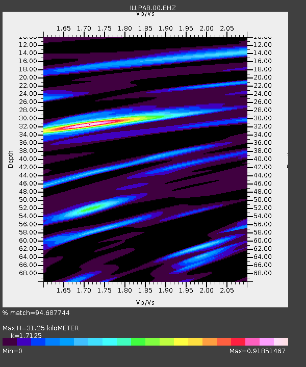
| Estimated Moho Depth: |
31.25 km |
| Estimated Crust Vp/Vs: |
1.71 |
| Assumed Crust Vp: |
6.276 km/s |
| Estimated Crust Vs: |
3.665 km/s |
| Estimated Crust Poisson's Ratio: |
0.24 |
|
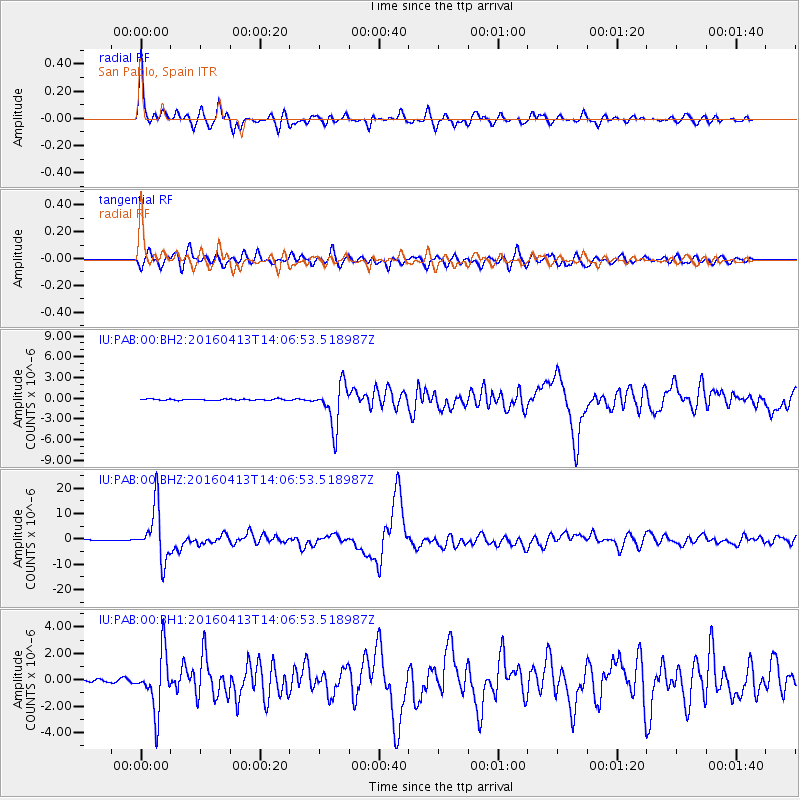
| Radial Match: |
94.687744 % |
| Radial Bump: |
378 |
| Transverse Match: |
87.70221 % |
| Transverse Bump: |
400 |
| SOD ConfigId: |
1475611 |
| Insert Time: |
2016-04-27 14:12:05.897 +0000 |
| GWidth: |
2.5 |
| Max Bumps: |
400 |
| Tol: |
0.001 |
|
Signal To Noise
| Channel | StoN | STA | LTA |
| IU:PAB:00:BHZ:20160413T14:06:53.518987Z | 81.736305 | 1.0465334E-5 | 1.2803775E-7 |
| IU:PAB:00:BH1:20160413T14:06:53.518987Z | 16.525146 | 2.1675567E-6 | 1.3116717E-7 |
| IU:PAB:00:BH2:20160413T14:06:53.518987Z | 32.66237 | 3.1068862E-6 | 9.512129E-8 |
| Arrivals |
| Ps | 3.6 SECOND |
| PpPs | 13 SECOND |
| PsPs/PpSs | 17 SECOND |


