You are here: Home > Network List > YT07 - POLENET Stations List
> Station RMBO RMBO > Earthquake Result Viewer
RMBO RMBO - Earthquake Result Viewer
| Earthquake location: |
Eastern New Guinea Reg., P.N.G. |
| Earthquake latitude/longitude: |
-6.1/147.6 |
| Earthquake time(UTC): |
2017/12/01 (335) 02:49:59 GMT |
| Earthquake Depth: |
40 km |
| Earthquake Magnitude: |
6.0 Mww |
| Earthquake Catalog/Contributor: |
NEIC PDE/us |
|
| Network: |
YT POLENET |
| Station: |
RMBO RMBO |
| Lat/Lon: |
83.87 S/66.40 W |
| Elevation: |
800 m |
|
| Distance: |
89.0 deg |
| Az: |
176.552 deg |
| Baz: |
213.813 deg |
| Ray Param: |
0.042078238 |
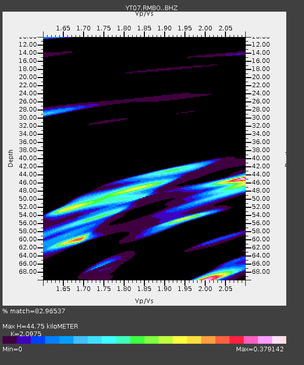
| Estimated Moho Depth: |
44.75 km |
| Estimated Crust Vp/Vs: |
2.10 |
| Assumed Crust Vp: |
6.356 km/s |
| Estimated Crust Vs: |
3.03 km/s |
| Estimated Crust Poisson's Ratio: |
0.35 |
|
| Radial Match: |
82.96537 % |
| Radial Bump: |
388 |
| Transverse Match: |
85.88201 % |
| Transverse Bump: |
400 |
| SOD ConfigId: |
13570011 |
| Insert Time: |
2019-04-29 08:46:52.287 +0000 |
| GWidth: |
2.5 |
| Max Bumps: |
400 |
| Tol: |
0.001 |
|

Signal To Noise
| Channel | StoN | STA | LTA |
| YT:RMBO: :BHZ:20171201T03:02:18.848975Z | 5.3292403 | 1.7220513E-6 | 3.2313258E-7 |
| YT:RMBO: :BHN:20171201T03:02:18.848975Z | 1.6279627 | 4.77385E-7 | 2.9324073E-7 |
| YT:RMBO: :BHE:20171201T03:02:18.848975Z | 2.6374369 | 4.4552914E-7 | 1.6892504E-7 |
| Arrivals |
| Ps | 7.9 SECOND |
| PpPs | 21 SECOND |
| PsPs/PpSs | 29 SECOND |


