You are here: Home > Network List > IU - Global Seismograph Network (GSN - IRIS/USGS) Stations List
> Station TSUM Tsumeb, Namibia > Earthquake Result Viewer
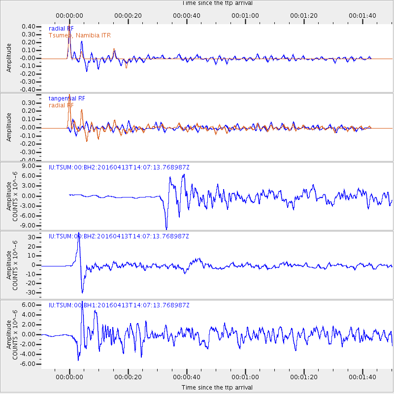
TSUM Tsumeb, Namibia - Earthquake Result Viewer

| Earthquake location: |
Myanmar-India Border Region |
| Earthquake latitude/longitude: |
23.1/94.9 |
| Earthquake time(UTC): |
2016/04/13 (104) 13:55:17 GMT |
| Earthquake Depth: |
135 km |
| Earthquake Magnitude: |
6.9 MWB |
| Earthquake Catalog/Contributor: |
NEIC PDE/NEIC COMCAT |
|
| Network: |
IU Global Seismograph Network (GSN - IRIS/USGS) |
| Station: |
TSUM Tsumeb, Namibia |
| Lat/Lon: |
19.20 S/17.58 E |
| Elevation: |
1260 m |
|
| Distance: |
86.4 deg |
| Az: |
247.493 deg |
| Baz: |
64.143 deg |
| Ray Param: |
0.04380081 |
| Estimated Moho Depth: |
38.25 km |
| Estimated Crust Vp/Vs: |
1.70 |
| Assumed Crust Vp: |
6.51 km/s |
| Estimated Crust Vs: |
3.824 km/s |
| Estimated Crust Poisson's Ratio: |
0.24 |
|
| Radial Match: |
92.00373 % |
| Radial Bump: |
379 |
| Transverse Match: |
86.59746 % |
| Transverse Bump: |
400 |
| SOD ConfigId: |
1475611 |
| Insert Time: |
2016-04-27 14:12:55.476 +0000 |
| GWidth: |
2.5 |
| Max Bumps: |
400 |
| Tol: |
0.001 |
|
Signal To Noise
| Channel | StoN | STA | LTA |
| IU:TSUM:00:BHZ:20160413T14:07:13.768987Z | 137.27951 | 1.621182E-5 | 1.1809352E-7 |
| IU:TSUM:00:BH1:20160413T14:07:13.768987Z | 12.631675 | 2.687555E-6 | 2.1276315E-7 |
| IU:TSUM:00:BH2:20160413T14:07:13.768987Z | 12.231128 | 3.95602E-6 | 3.234387E-7 |
| Arrivals |
| Ps | 4.2 SECOND |
| PpPs | 15 SECOND |
| PsPs/PpSs | 20 SECOND |


