You are here: Home > Network List > AK - Alaska Regional Network Stations List
> Station MDM Murphy Dome > Earthquake Result Viewer
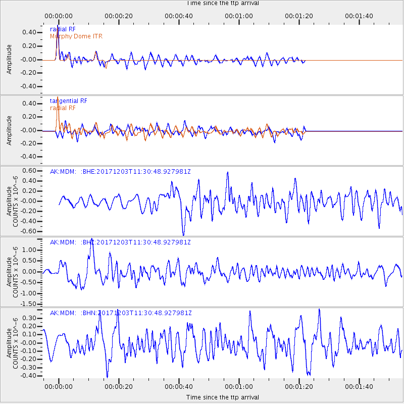
MDM Murphy Dome - Earthquake Result Viewer
*The percent match for this event was below the threshold and hence no stack was calculated.
| Earthquake location: |
Near Coast Of Ecuador |
| Earthquake latitude/longitude: |
-0.5/-80.3 |
| Earthquake time(UTC): |
2017/12/03 (337) 11:19:06 GMT |
| Earthquake Depth: |
25 km |
| Earthquake Magnitude: |
6.0 Mww |
| Earthquake Catalog/Contributor: |
NEIC PDE/us |
|
| Network: |
AK Alaska Regional Network |
| Station: |
MDM Murphy Dome |
| Lat/Lon: |
64.96 N/148.23 W |
| Elevation: |
634 m |
|
| Distance: |
81.2 deg |
| Az: |
336.477 deg |
| Baz: |
110.327 deg |
| Ray Param: |
$rayparam |
*The percent match for this event was below the threshold and hence was not used in the summary stack. |
|
| Radial Match: |
74.615906 % |
| Radial Bump: |
400 |
| Transverse Match: |
68.68151 % |
| Transverse Bump: |
400 |
| SOD ConfigId: |
13570011 |
| Insert Time: |
2019-04-29 08:49:39.008 +0000 |
| GWidth: |
2.5 |
| Max Bumps: |
400 |
| Tol: |
0.001 |
|
Signal To Noise
| Channel | StoN | STA | LTA |
| AK:MDM: :BHZ:20171203T11:30:48.927981Z | 3.1479616 | 3.6532518E-7 | 1.16051346E-7 |
| AK:MDM: :BHN:20171203T11:30:48.927981Z | 1.1892368 | 9.469364E-8 | 7.962555E-8 |
| AK:MDM: :BHE:20171203T11:30:48.927981Z | 1.621728 | 1.2580188E-7 | 7.7572736E-8 |
| Arrivals |
| Ps | |
| PpPs | |
| PsPs/PpSs | |


