You are here: Home > Network List > ND - New CaleDonia Broadband Seismic Network Stations List
> Station LIFNC Lifou, Loyalty Islands, New Caledonia > Earthquake Result Viewer
LIFNC Lifou, Loyalty Islands, New Caledonia - Earthquake Result Viewer
| Earthquake location: |
Myanmar-India Border Region |
| Earthquake latitude/longitude: |
23.1/94.9 |
| Earthquake time(UTC): |
2016/04/13 (104) 13:55:17 GMT |
| Earthquake Depth: |
135 km |
| Earthquake Magnitude: |
6.9 MWB |
| Earthquake Catalog/Contributor: |
NEIC PDE/NEIC COMCAT |
|
| Network: |
ND New CaleDonia Broadband Seismic Network |
| Station: |
LIFNC Lifou, Loyalty Islands, New Caledonia |
| Lat/Lon: |
20.78 S/167.24 E |
| Elevation: |
33 m |
|
| Distance: |
82.9 deg |
| Az: |
116.033 deg |
| Baz: |
297.879 deg |
| Ray Param: |
0.046257082 |
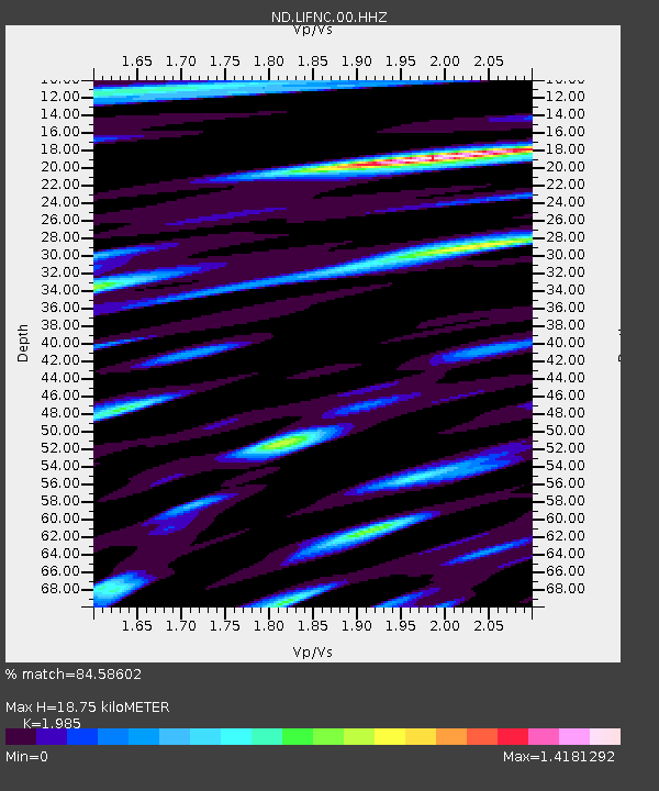
| Estimated Moho Depth: |
18.75 km |
| Estimated Crust Vp/Vs: |
1.99 |
| Assumed Crust Vp: |
4.662 km/s |
| Estimated Crust Vs: |
2.349 km/s |
| Estimated Crust Poisson's Ratio: |
0.33 |
|
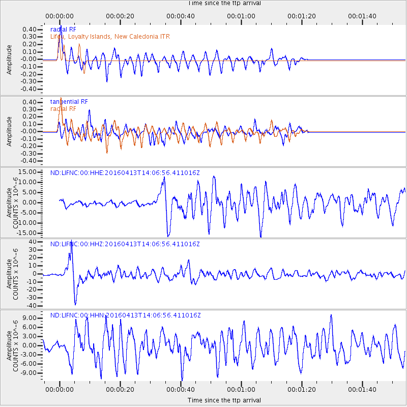
| Radial Match: |
84.58602 % |
| Radial Bump: |
400 |
| Transverse Match: |
73.656654 % |
| Transverse Bump: |
400 |
| SOD ConfigId: |
1475611 |
| Insert Time: |
2016-04-27 14:13:47.841 +0000 |
| GWidth: |
2.5 |
| Max Bumps: |
400 |
| Tol: |
0.001 |
|
Signal To Noise
| Channel | StoN | STA | LTA |
| ND:LIFNC:00:HHZ:20160413T14:06:56.411016Z | 19.436157 | 1.4609542E-5 | 7.516682E-7 |
| ND:LIFNC:00:HHN:20160413T14:06:56.411016Z | 2.4290457 | 3.595618E-6 | 1.4802596E-6 |
| ND:LIFNC:00:HHE:20160413T14:06:56.411016Z | 5.617188 | 5.357357E-6 | 9.537436E-7 |
| Arrivals |
| Ps | 4.0 SECOND |
| PpPs | 12 SECOND |
| PsPs/PpSs | 16 SECOND |


