You are here: Home > Network List > AV - Alaska Volcano Observatory Stations List
> Station SPCR Ckakachatna River, Mount Spurr, Alaska > Earthquake Result Viewer
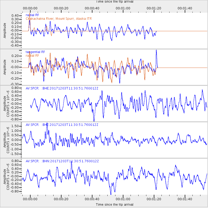
SPCR Ckakachatna River, Mount Spurr, Alaska - Earthquake Result Viewer
*The percent match for this event was below the threshold and hence no stack was calculated.
| Earthquake location: |
Near Coast Of Ecuador |
| Earthquake latitude/longitude: |
-0.5/-80.3 |
| Earthquake time(UTC): |
2017/12/03 (337) 11:19:06 GMT |
| Earthquake Depth: |
25 km |
| Earthquake Magnitude: |
6.0 Mww |
| Earthquake Catalog/Contributor: |
NEIC PDE/us |
|
| Network: |
AV Alaska Volcano Observatory |
| Station: |
SPCR Ckakachatna River, Mount Spurr, Alaska |
| Lat/Lon: |
61.20 N/152.21 W |
| Elevation: |
984 m |
|
| Distance: |
81.8 deg |
| Az: |
332.282 deg |
| Baz: |
106.162 deg |
| Ray Param: |
$rayparam |
*The percent match for this event was below the threshold and hence was not used in the summary stack. |
|
| Radial Match: |
54.11892 % |
| Radial Bump: |
400 |
| Transverse Match: |
61.969303 % |
| Transverse Bump: |
400 |
| SOD ConfigId: |
13570011 |
| Insert Time: |
2019-04-29 08:50:08.400 +0000 |
| GWidth: |
2.5 |
| Max Bumps: |
400 |
| Tol: |
0.001 |
|
Signal To Noise
| Channel | StoN | STA | LTA |
| AV:SPCR: :BHZ:20171203T11:30:51.760012Z | 2.3383083 | 4.8559104E-7 | 2.0766768E-7 |
| AV:SPCR: :BHN:20171203T11:30:51.760012Z | 0.76336414 | 1.4326109E-7 | 1.8767071E-7 |
| AV:SPCR: :BHE:20171203T11:30:51.760012Z | 0.8574223 | 1.7236248E-7 | 2.0102402E-7 |
| Arrivals |
| Ps | |
| PpPs | |
| PsPs/PpSs | |


