You are here: Home > Network List > CI - Caltech Regional Seismic Network Stations List
> Station TIN Tinemaha, Big Pine, CA, USA > Earthquake Result Viewer
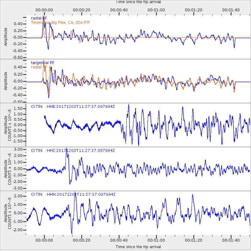
TIN Tinemaha, Big Pine, CA, USA - Earthquake Result Viewer
*The percent match for this event was below the threshold and hence no stack was calculated.
| Earthquake location: |
Near Coast Of Ecuador |
| Earthquake latitude/longitude: |
-0.5/-80.3 |
| Earthquake time(UTC): |
2017/12/03 (337) 11:19:06 GMT |
| Earthquake Depth: |
25 km |
| Earthquake Magnitude: |
6.0 Mww |
| Earthquake Catalog/Contributor: |
NEIC PDE/us |
|
| Network: |
CI Caltech Regional Seismic Network |
| Station: |
TIN Tinemaha, Big Pine, CA, USA |
| Lat/Lon: |
37.05 N/118.23 W |
| Elevation: |
1197 m |
|
| Distance: |
51.3 deg |
| Az: |
320.896 deg |
| Baz: |
127.966 deg |
| Ray Param: |
$rayparam |
*The percent match for this event was below the threshold and hence was not used in the summary stack. |
|
| Radial Match: |
74.83885 % |
| Radial Bump: |
400 |
| Transverse Match: |
52.730022 % |
| Transverse Bump: |
400 |
| SOD ConfigId: |
13570011 |
| Insert Time: |
2019-04-29 08:51:28.111 +0000 |
| GWidth: |
2.5 |
| Max Bumps: |
400 |
| Tol: |
0.001 |
|
Signal To Noise
| Channel | StoN | STA | LTA |
| CI:TIN: :HHZ:20171203T11:27:37.097994Z | 0.6914254 | 1.7828835E-7 | 2.5785624E-7 |
| CI:TIN: :HHN:20171203T11:27:37.097994Z | 0.90136135 | 5.173581E-7 | 5.7397415E-7 |
| CI:TIN: :HHE:20171203T11:27:37.097994Z | 0.88542354 | 2.4910634E-7 | 2.8134144E-7 |
| Arrivals |
| Ps | |
| PpPs | |
| PsPs/PpSs | |


