You are here: Home > Network List > TA - USArray Transportable Network (new EarthScope stations) Stations List
> Station Q20A Ridgley Place, Grand Junction, CO, USA > Earthquake Result Viewer
Q20A Ridgley Place, Grand Junction, CO, USA - Earthquake Result Viewer

| Earthquake location: |
Near S. Coast Of Honshu, Japan |
| Earthquake latitude/longitude: |
33.2/137.9 |
| Earthquake time(UTC): |
2009/08/09 (221) 10:55:55 GMT |
| Earthquake Depth: |
297 km |
| Earthquake Magnitude: |
6.5 MB, 7.1 MW, 7.1 MW |
| Earthquake Catalog/Contributor: |
WHDF/NEIC |
|
| Network: |
TA USArray Transportable Network (new EarthScope stations) |
| Station: |
Q20A Ridgley Place, Grand Junction, CO, USA |
| Lat/Lon: |
38.95 N/108.30 W |
| Elevation: |
1716 m |
|
| Distance: |
85.6 deg |
| Az: |
45.705 deg |
| Baz: |
309.65 deg |
| Ray Param: |
0.043939464 |
| Estimated Moho Depth: |
42.5 km |
| Estimated Crust Vp/Vs: |
2.10 |
| Assumed Crust Vp: |
6.291 km/s |
| Estimated Crust Vs: |
2.999 km/s |
| Estimated Crust Poisson's Ratio: |
0.35 |
|
| Radial Match: |
94.57976 % |
| Radial Bump: |
400 |
| Transverse Match: |
88.37894 % |
| Transverse Bump: |
400 |
| SOD ConfigId: |
2622 |
| Insert Time: |
2010-03-06 07:10:19.646 +0000 |
| GWidth: |
2.5 |
| Max Bumps: |
400 |
| Tol: |
0.001 |
|
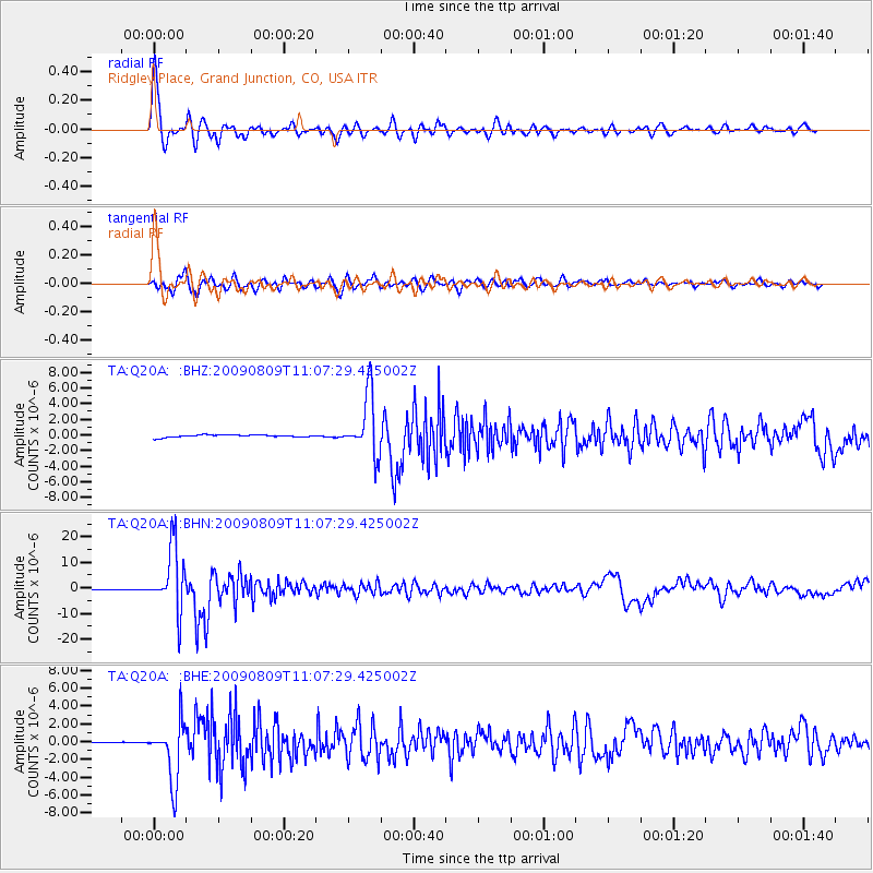
Signal To Noise
| Channel | StoN | STA | LTA |
| TA:Q20A: :BHN:20090809T11:07:29.425002Z | 163.5034 | 1.24213475E-5 | 7.5969965E-8 |
| TA:Q20A: :BHE:20090809T11:07:29.425002Z | 36.699295 | 3.3159115E-6 | 9.0353545E-8 |
| TA:Q20A: :BHZ:20090809T11:07:29.425002Z | 25.381842 | 3.8679113E-6 | 1.5238892E-7 |
| Arrivals |
| Ps | 7.6 SECOND |
| PpPs | 21 SECOND |
| PsPs/PpSs | 28 SECOND |


