You are here: Home > Network List > CN - Canadian National Seismograph Network Stations List
> Station INK INUVIK, NT > Earthquake Result Viewer
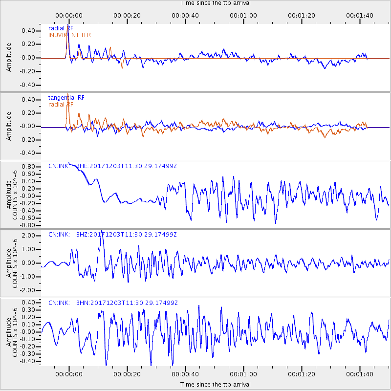
INK INUVIK, NT - Earthquake Result Viewer
*The percent match for this event was below the threshold and hence no stack was calculated.
| Earthquake location: |
Near Coast Of Ecuador |
| Earthquake latitude/longitude: |
-0.5/-80.3 |
| Earthquake time(UTC): |
2017/12/03 (337) 11:19:06 GMT |
| Earthquake Depth: |
25 km |
| Earthquake Magnitude: |
6.0 Mww |
| Earthquake Catalog/Contributor: |
NEIC PDE/us |
|
| Network: |
CN Canadian National Seismograph Network |
| Station: |
INK INUVIK, NT |
| Lat/Lon: |
68.31 N/133.53 W |
| Elevation: |
44 m |
|
| Distance: |
77.6 deg |
| Az: |
342.243 deg |
| Baz: |
124.887 deg |
| Ray Param: |
$rayparam |
*The percent match for this event was below the threshold and hence was not used in the summary stack. |
|
| Radial Match: |
48.432816 % |
| Radial Bump: |
400 |
| Transverse Match: |
39.599937 % |
| Transverse Bump: |
400 |
| SOD ConfigId: |
13570011 |
| Insert Time: |
2019-04-29 08:51:52.487 +0000 |
| GWidth: |
2.5 |
| Max Bumps: |
400 |
| Tol: |
0.001 |
|
Signal To Noise
| Channel | StoN | STA | LTA |
| CN:INK: :BHZ:20171203T11:30:29.17499Z | 5.414716 | 6.232859E-7 | 1.15109636E-7 |
| CN:INK: :BHN:20171203T11:30:29.17499Z | 1.6050197 | 1.4327739E-7 | 8.9268305E-8 |
| CN:INK: :BHE:20171203T11:30:29.17499Z | 0.81913996 | 2.9782152E-7 | 3.635783E-7 |
| Arrivals |
| Ps | |
| PpPs | |
| PsPs/PpSs | |


