You are here: Home > Network List > TA - USArray Transportable Network (new EarthScope stations) Stations List
> Station Q20A Ridgley Place, Grand Junction, CO, USA > Earthquake Result Viewer
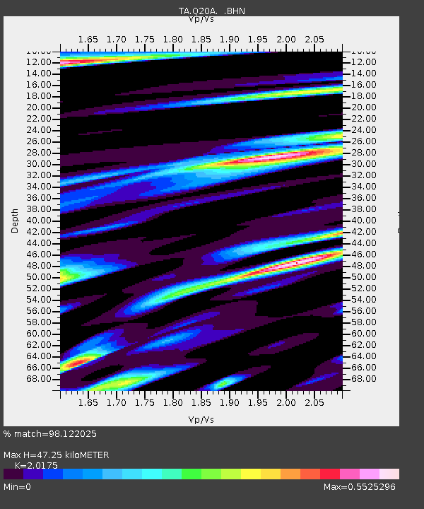
Q20A Ridgley Place, Grand Junction, CO, USA - Earthquake Result Viewer
| Earthquake location: |
Samoa Islands Region |
| Earthquake latitude/longitude: |
-15.5/-172.1 |
| Earthquake time(UTC): |
2009/09/29 (272) 17:48:10 GMT |
| Earthquake Depth: |
18 km |
| Earthquake Magnitude: |
7.1 MB, 8.1 MS, 8.1 MW, 8.0 MW |
| Earthquake Catalog/Contributor: |
WHDF/NEIC |
|
| Network: |
TA USArray Transportable Network (new EarthScope stations) |
| Station: |
Q20A Ridgley Place, Grand Junction, CO, USA |
| Lat/Lon: |
38.95 N/108.30 W |
| Elevation: |
1716 m |
|
| Distance: |
80.5 deg |
| Az: |
45.187 deg |
| Baz: |
241.308 deg |
| Ray Param: |
0.0482469 |
| Estimated Moho Depth: |
47.25 km |
| Estimated Crust Vp/Vs: |
2.02 |
| Assumed Crust Vp: |
6.291 km/s |
| Estimated Crust Vs: |
3.118 km/s |
| Estimated Crust Poisson's Ratio: |
0.34 |
|
| Radial Match: |
98.122025 % |
| Radial Bump: |
400 |
| Transverse Match: |
86.389 % |
| Transverse Bump: |
400 |
| SOD ConfigId: |
2622 |
| Insert Time: |
2010-03-06 07:10:35.330 +0000 |
| GWidth: |
2.5 |
| Max Bumps: |
400 |
| Tol: |
0.001 |
|

Signal To Noise
| Channel | StoN | STA | LTA |
| TA:Q20A: :BHN:20090929T17:59:50.224009Z | 13.728628 | 3.1418333E-6 | 2.2885267E-7 |
| TA:Q20A: :BHE:20090929T17:59:50.224009Z | 5.9186 | 5.415582E-7 | 9.150107E-8 |
| TA:Q20A: :BHZ:20090929T17:59:50.224009Z | 9.921711 | 1.2388706E-6 | 1.2486461E-7 |
| Arrivals |
| Ps | 7.8 SECOND |
| PpPs | 22 SECOND |
| PsPs/PpSs | 30 SECOND |


