You are here: Home > Network List > LD - Lamont-Doherty Cooperative Seismographic Network Stations List
> Station GEDE Greenville, DE, USA > Earthquake Result Viewer
GEDE Greenville, DE, USA - Earthquake Result Viewer
| Earthquake location: |
Near Coast Of Ecuador |
| Earthquake latitude/longitude: |
-0.5/-80.3 |
| Earthquake time(UTC): |
2017/12/03 (337) 11:19:06 GMT |
| Earthquake Depth: |
25 km |
| Earthquake Magnitude: |
6.0 Mww |
| Earthquake Catalog/Contributor: |
NEIC PDE/us |
|
| Network: |
LD Lamont-Doherty Cooperative Seismographic Network |
| Station: |
GEDE Greenville, DE, USA |
| Lat/Lon: |
39.81 N/75.64 W |
| Elevation: |
105 m |
|
| Distance: |
40.3 deg |
| Az: |
5.533 deg |
| Baz: |
187.191 deg |
| Ray Param: |
0.07442586 |
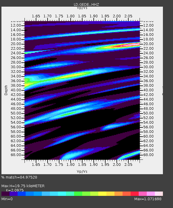
| Estimated Moho Depth: |
19.75 km |
| Estimated Crust Vp/Vs: |
2.10 |
| Assumed Crust Vp: |
6.287 km/s |
| Estimated Crust Vs: |
2.998 km/s |
| Estimated Crust Poisson's Ratio: |
0.35 |
|
| Radial Match: |
84.97528 % |
| Radial Bump: |
400 |
| Transverse Match: |
63.012096 % |
| Transverse Bump: |
400 |
| SOD ConfigId: |
13570011 |
| Insert Time: |
2019-04-29 08:53:21.922 +0000 |
| GWidth: |
2.5 |
| Max Bumps: |
400 |
| Tol: |
0.001 |
|
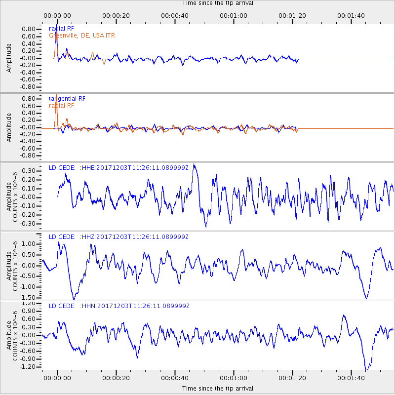
Signal To Noise
| Channel | StoN | STA | LTA |
| LD:GEDE: :HHZ:20171203T11:26:11.089999Z | 7.0837526 | 7.2789146E-7 | 1.0275507E-7 |
| LD:GEDE: :HHN:20171203T11:26:11.089999Z | 3.6216114 | 3.1647318E-7 | 8.7384635E-8 |
| LD:GEDE: :HHE:20171203T11:26:11.089999Z | 1.1782244 | 1.1126861E-7 | 9.443753E-8 |
| Arrivals |
| Ps | 3.6 SECOND |
| PpPs | 9.2 SECOND |
| PsPs/PpSs | 13 SECOND |


