You are here: Home > Network List > LX - University of LISbon SEISmic Network Stations List
> Station MORF Marmelete, Algarve, Portugal > Earthquake Result Viewer
MORF Marmelete, Algarve, Portugal - Earthquake Result Viewer
| Earthquake location: |
Near Coast Of Ecuador |
| Earthquake latitude/longitude: |
-0.5/-80.3 |
| Earthquake time(UTC): |
2017/12/03 (337) 11:19:06 GMT |
| Earthquake Depth: |
25 km |
| Earthquake Magnitude: |
6.0 Mww |
| Earthquake Catalog/Contributor: |
NEIC PDE/us |
|
| Network: |
LX University of LISbon SEISmic Network |
| Station: |
MORF Marmelete, Algarve, Portugal |
| Lat/Lon: |
37.30 N/8.65 W |
| Elevation: |
560 m |
|
| Distance: |
75.7 deg |
| Az: |
51.333 deg |
| Baz: |
258.28 deg |
| Ray Param: |
0.05143175 |
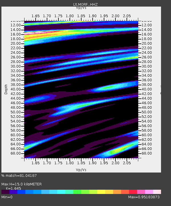
| Estimated Moho Depth: |
15.0 km |
| Estimated Crust Vp/Vs: |
1.64 |
| Assumed Crust Vp: |
6.048 km/s |
| Estimated Crust Vs: |
3.677 km/s |
| Estimated Crust Poisson's Ratio: |
0.21 |
|
| Radial Match: |
81.04187 % |
| Radial Bump: |
311 |
| Transverse Match: |
60.23879 % |
| Transverse Bump: |
400 |
| SOD ConfigId: |
13570011 |
| Insert Time: |
2019-04-29 08:53:39.721 +0000 |
| GWidth: |
2.5 |
| Max Bumps: |
400 |
| Tol: |
0.001 |
|

Signal To Noise
| Channel | StoN | STA | LTA |
| LX:MORF: :HHZ:20171203T11:30:18.864993Z | 4.8671317 | 1.0657028E-6 | 2.189591E-7 |
| LX:MORF: :HHN:20171203T11:30:18.864993Z | 1.24717 | 2.8315944E-7 | 2.2704158E-7 |
| LX:MORF: :HHE:20171203T11:30:18.864993Z | 1.7756053 | 4.905537E-7 | 2.7627405E-7 |
| Arrivals |
| Ps | 1.6 SECOND |
| PpPs | 6.4 SECOND |
| PsPs/PpSs | 8.0 SECOND |


