You are here: Home > Network List > N4 - Central and EAstern US Network Stations List
> Station U59A Littleton, NC, USA > Earthquake Result Viewer
U59A Littleton, NC, USA - Earthquake Result Viewer
| Earthquake location: |
Near Coast Of Ecuador |
| Earthquake latitude/longitude: |
-0.5/-80.3 |
| Earthquake time(UTC): |
2017/12/03 (337) 11:19:06 GMT |
| Earthquake Depth: |
25 km |
| Earthquake Magnitude: |
6.0 Mww |
| Earthquake Catalog/Contributor: |
NEIC PDE/us |
|
| Network: |
N4 Central and EAstern US Network |
| Station: |
U59A Littleton, NC, USA |
| Lat/Lon: |
36.35 N/77.79 W |
| Elevation: |
99 m |
|
| Distance: |
36.7 deg |
| Az: |
3.362 deg |
| Baz: |
184.166 deg |
| Ray Param: |
0.07648739 |
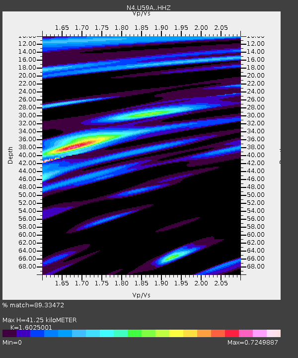
| Estimated Moho Depth: |
41.25 km |
| Estimated Crust Vp/Vs: |
1.60 |
| Assumed Crust Vp: |
6.565 km/s |
| Estimated Crust Vs: |
4.096 km/s |
| Estimated Crust Poisson's Ratio: |
0.18 |
|
| Radial Match: |
89.33472 % |
| Radial Bump: |
347 |
| Transverse Match: |
63.742996 % |
| Transverse Bump: |
400 |
| SOD ConfigId: |
13570011 |
| Insert Time: |
2019-04-29 08:55:20.187 +0000 |
| GWidth: |
2.5 |
| Max Bumps: |
400 |
| Tol: |
0.001 |
|

Signal To Noise
| Channel | StoN | STA | LTA |
| N4:U59A: :HHZ:20171203T11:25:40.850009Z | 6.645357 | 6.736839E-7 | 1.01376635E-7 |
| N4:U59A: :HHN:20171203T11:25:40.850009Z | 4.799445 | 4.4194437E-7 | 9.208239E-8 |
| N4:U59A: :HHE:20171203T11:25:40.850009Z | 1.4105642 | 1.0345E-7 | 7.333945E-8 |
| Arrivals |
| Ps | 4.1 SECOND |
| PpPs | 15 SECOND |
| PsPs/PpSs | 19 SECOND |


