You are here: Home > Network List > OK - Oklahoma Seismic Network Stations List
> Station U32A Winter Ranch, Mooreland, Oklahoma, USA > Earthquake Result Viewer
U32A Winter Ranch, Mooreland, Oklahoma, USA - Earthquake Result Viewer
| Earthquake location: |
Near Coast Of Ecuador |
| Earthquake latitude/longitude: |
-0.5/-80.3 |
| Earthquake time(UTC): |
2017/12/03 (337) 11:19:06 GMT |
| Earthquake Depth: |
25 km |
| Earthquake Magnitude: |
6.0 Mww |
| Earthquake Catalog/Contributor: |
NEIC PDE/us |
|
| Network: |
OK Oklahoma Seismic Network |
| Station: |
U32A Winter Ranch, Mooreland, Oklahoma, USA |
| Lat/Lon: |
36.38 N/99.00 W |
| Elevation: |
525 m |
|
| Distance: |
40.6 deg |
| Az: |
336.546 deg |
| Baz: |
150.45 deg |
| Ray Param: |
0.07427035 |
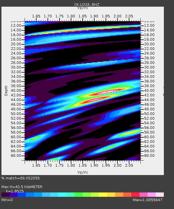
| Estimated Moho Depth: |
40.5 km |
| Estimated Crust Vp/Vs: |
1.95 |
| Assumed Crust Vp: |
6.426 km/s |
| Estimated Crust Vs: |
3.291 km/s |
| Estimated Crust Poisson's Ratio: |
0.32 |
|
| Radial Match: |
88.052055 % |
| Radial Bump: |
400 |
| Transverse Match: |
64.82081 % |
| Transverse Bump: |
400 |
| SOD ConfigId: |
13570011 |
| Insert Time: |
2019-04-29 08:56:11.898 +0000 |
| GWidth: |
2.5 |
| Max Bumps: |
400 |
| Tol: |
0.001 |
|

Signal To Noise
| Channel | StoN | STA | LTA |
| OK:U32A: :BHZ:20171203T11:26:13.17499Z | 3.2037406 | 5.3161943E-7 | 1.6593711E-7 |
| OK:U32A: :BHN:20171203T11:26:13.17499Z | 1.3550712 | 2.1703956E-7 | 1.6016838E-7 |
| OK:U32A: :BHE:20171203T11:26:13.17499Z | 1.5358022 | 3.085964E-7 | 2.0093499E-7 |
| Arrivals |
| Ps | 6.4 SECOND |
| PpPs | 17 SECOND |
| PsPs/PpSs | 24 SECOND |


