You are here: Home > Network List > ON - RSIS-Rede Sismografica do Sul e Sudeste Observatorio Nacional, Brazil Stations List
> Station GUA01 "OBSN: [GUA01] Guaratinga, BA" > Earthquake Result Viewer
GUA01 "OBSN: [GUA01] Guaratinga, BA" - Earthquake Result Viewer
| Earthquake location: |
Near Coast Of Ecuador |
| Earthquake latitude/longitude: |
-0.5/-80.3 |
| Earthquake time(UTC): |
2017/12/03 (337) 11:19:06 GMT |
| Earthquake Depth: |
25 km |
| Earthquake Magnitude: |
6.0 Mww |
| Earthquake Catalog/Contributor: |
NEIC PDE/us |
|
| Network: |
ON RSIS-Rede Sismografica do Sul e Sudeste Observatorio Nacional, Brazil |
| Station: |
GUA01 "OBSN: [GUA01] Guaratinga, BA" |
| Lat/Lon: |
16.58 S/39.81 W |
| Elevation: |
198 m |
|
| Distance: |
43.0 deg |
| Az: |
114.029 deg |
| Baz: |
287.744 deg |
| Ray Param: |
0.0728141 |
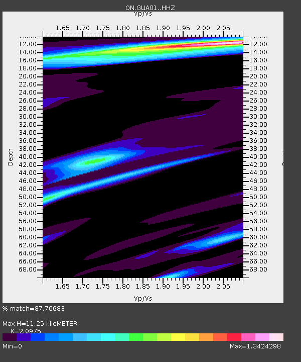
| Estimated Moho Depth: |
11.25 km |
| Estimated Crust Vp/Vs: |
2.10 |
| Assumed Crust Vp: |
6.391 km/s |
| Estimated Crust Vs: |
3.047 km/s |
| Estimated Crust Poisson's Ratio: |
0.35 |
|
| Radial Match: |
87.70683 % |
| Radial Bump: |
371 |
| Transverse Match: |
66.24342 % |
| Transverse Bump: |
400 |
| SOD ConfigId: |
13570011 |
| Insert Time: |
2019-04-29 08:56:13.912 +0000 |
| GWidth: |
2.5 |
| Max Bumps: |
400 |
| Tol: |
0.001 |
|

Signal To Noise
| Channel | StoN | STA | LTA |
| ON:GUA01: :HHZ:20171203T11:26:32.787997Z | 8.342803 | 1.1461591E-6 | 1.3738297E-7 |
| ON:GUA01: :HHN:20171203T11:26:32.787997Z | 1.9147588 | 2.898759E-7 | 1.513903E-7 |
| ON:GUA01: :HHE:20171203T11:26:32.787997Z | 4.172073 | 6.459054E-7 | 1.5481643E-7 |
| Arrivals |
| Ps | 2.0 SECOND |
| PpPs | 5.2 SECOND |
| PsPs/PpSs | 7.2 SECOND |


