You are here: Home > Network List > PE - Penn State Network Stations List
> Station PACF Cook Forest State Park, Cooksburg, PA > Earthquake Result Viewer
PACF Cook Forest State Park, Cooksburg, PA - Earthquake Result Viewer
| Earthquake location: |
Near Coast Of Ecuador |
| Earthquake latitude/longitude: |
-0.5/-80.3 |
| Earthquake time(UTC): |
2017/12/03 (337) 11:19:06 GMT |
| Earthquake Depth: |
25 km |
| Earthquake Magnitude: |
6.0 Mww |
| Earthquake Catalog/Contributor: |
NEIC PDE/us |
|
| Network: |
PE Penn State Network |
| Station: |
PACF Cook Forest State Park, Cooksburg, PA |
| Lat/Lon: |
41.33 N/79.21 W |
| Elevation: |
398 m |
|
| Distance: |
41.6 deg |
| Az: |
1.217 deg |
| Baz: |
181.617 deg |
| Ray Param: |
0.07362633 |
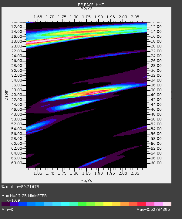
| Estimated Moho Depth: |
17.25 km |
| Estimated Crust Vp/Vs: |
1.69 |
| Assumed Crust Vp: |
6.121 km/s |
| Estimated Crust Vs: |
3.622 km/s |
| Estimated Crust Poisson's Ratio: |
0.23 |
|
| Radial Match: |
80.21678 % |
| Radial Bump: |
375 |
| Transverse Match: |
49.23861 % |
| Transverse Bump: |
387 |
| SOD ConfigId: |
13570011 |
| Insert Time: |
2019-04-29 08:56:30.294 +0000 |
| GWidth: |
2.5 |
| Max Bumps: |
400 |
| Tol: |
0.001 |
|

Signal To Noise
| Channel | StoN | STA | LTA |
| PE:PACF: :HHZ:20171203T11:26:21.82001Z | 3.654453 | 7.6928603E-7 | 2.1050647E-7 |
| PE:PACF: :HHN:20171203T11:26:21.82001Z | 2.705623 | 6.263721E-7 | 2.3150754E-7 |
| PE:PACF: :HHE:20171203T11:26:21.82001Z | 1.3346351 | 1.4840633E-7 | 1.1119618E-7 |
| Arrivals |
| Ps | 2.1 SECOND |
| PpPs | 7.1 SECOND |
| PsPs/PpSs | 9.2 SECOND |


