You are here: Home > Network List > TA - USArray Transportable Network (new EarthScope stations) Stations List
> Station E20K Nigu River, AK, USA > Earthquake Result Viewer
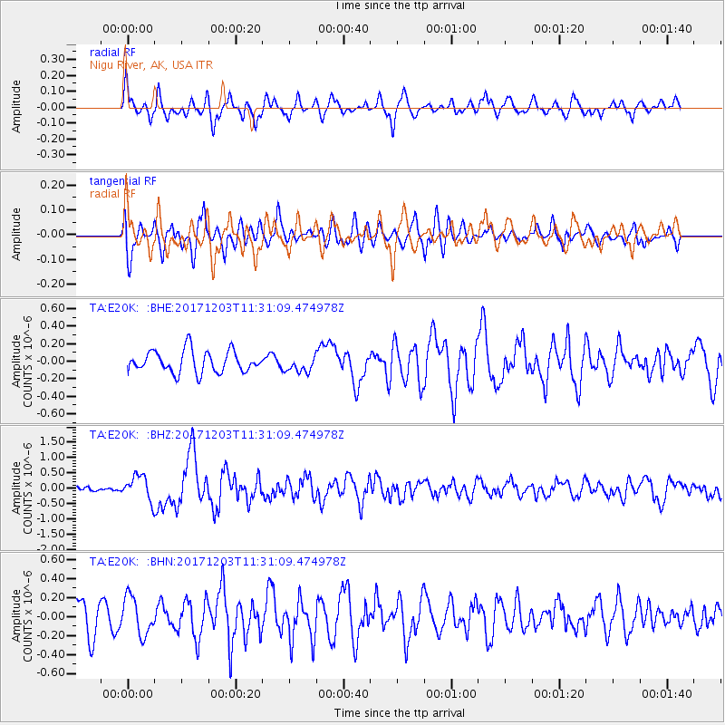
E20K Nigu River, AK, USA - Earthquake Result Viewer
*The percent match for this event was below the threshold and hence no stack was calculated.
| Earthquake location: |
Near Coast Of Ecuador |
| Earthquake latitude/longitude: |
-0.5/-80.3 |
| Earthquake time(UTC): |
2017/12/03 (337) 11:19:06 GMT |
| Earthquake Depth: |
25 km |
| Earthquake Magnitude: |
6.0 Mww |
| Earthquake Catalog/Contributor: |
NEIC PDE/us |
|
| Network: |
TA USArray Transportable Network (new EarthScope stations) |
| Station: |
E20K Nigu River, AK, USA |
| Lat/Lon: |
68.26 N/156.19 W |
| Elevation: |
866 m |
|
| Distance: |
85.2 deg |
| Az: |
338.739 deg |
| Baz: |
103.291 deg |
| Ray Param: |
$rayparam |
*The percent match for this event was below the threshold and hence was not used in the summary stack. |
|
| Radial Match: |
67.09007 % |
| Radial Bump: |
400 |
| Transverse Match: |
48.969948 % |
| Transverse Bump: |
400 |
| SOD ConfigId: |
13570011 |
| Insert Time: |
2019-04-29 08:57:40.197 +0000 |
| GWidth: |
2.5 |
| Max Bumps: |
400 |
| Tol: |
0.001 |
|
Signal To Noise
| Channel | StoN | STA | LTA |
| TA:E20K: :BHZ:20171203T11:31:09.474978Z | 2.4462414 | 4.1207664E-7 | 1.6845298E-7 |
| TA:E20K: :BHN:20171203T11:31:09.474978Z | 1.3111538 | 2.018322E-7 | 1.539348E-7 |
| TA:E20K: :BHE:20171203T11:31:09.474978Z | 0.7581821 | 9.3208406E-8 | 1.229367E-7 |
| Arrivals |
| Ps | |
| PpPs | |
| PsPs/PpSs | |


