You are here: Home > Network List > TA - USArray Transportable Network (new EarthScope stations) Stations List
> Station H31M Peel River, Yukon, CAN > Earthquake Result Viewer
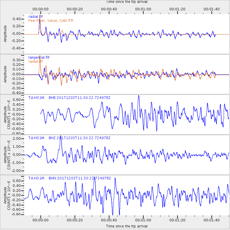
H31M Peel River, Yukon, CAN - Earthquake Result Viewer
*The percent match for this event was below the threshold and hence no stack was calculated.
| Earthquake location: |
Near Coast Of Ecuador |
| Earthquake latitude/longitude: |
-0.5/-80.3 |
| Earthquake time(UTC): |
2017/12/03 (337) 11:19:06 GMT |
| Earthquake Depth: |
25 km |
| Earthquake Magnitude: |
6.0 Mww |
| Earthquake Catalog/Contributor: |
NEIC PDE/us |
|
| Network: |
TA USArray Transportable Network (new EarthScope stations) |
| Station: |
H31M Peel River, Yukon, CAN |
| Lat/Lon: |
65.81 N/134.34 W |
| Elevation: |
642 m |
|
| Distance: |
76.5 deg |
| Az: |
339.926 deg |
| Baz: |
123.615 deg |
| Ray Param: |
$rayparam |
*The percent match for this event was below the threshold and hence was not used in the summary stack. |
|
| Radial Match: |
71.42319 % |
| Radial Bump: |
400 |
| Transverse Match: |
67.13847 % |
| Transverse Bump: |
400 |
| SOD ConfigId: |
13570011 |
| Insert Time: |
2019-04-29 08:58:14.208 +0000 |
| GWidth: |
2.5 |
| Max Bumps: |
400 |
| Tol: |
0.001 |
|
Signal To Noise
| Channel | StoN | STA | LTA |
| TA:H31M: :BHZ:20171203T11:30:22.724978Z | 6.935025 | 6.549294E-7 | 9.443792E-8 |
| TA:H31M: :BHN:20171203T11:30:22.724978Z | 1.7297108 | 1.9092145E-7 | 1.1037768E-7 |
| TA:H31M: :BHE:20171203T11:30:22.724978Z | 1.7412935 | 2.6902885E-7 | 1.5449942E-7 |
| Arrivals |
| Ps | |
| PpPs | |
| PsPs/PpSs | |


