You are here: Home > Network List > TA - USArray Transportable Network (new EarthScope stations) Stations List
> Station Q20A Ridgley Place, Grand Junction, CO, USA > Earthquake Result Viewer
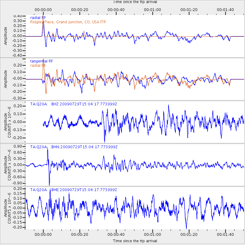
Q20A Ridgley Place, Grand Junction, CO, USA - Earthquake Result Viewer
*The percent match for this event was below the threshold and hence no stack was calculated.
| Earthquake location: |
Volcano Islands, Japan Region |
| Earthquake latitude/longitude: |
22.6/143.3 |
| Earthquake time(UTC): |
2009/07/29 (210) 14:52:08 GMT |
| Earthquake Depth: |
140 km |
| Earthquake Magnitude: |
5.5 MW, 5.2 MB, 5.4 MW |
| Earthquake Catalog/Contributor: |
WHDF/NEIC |
|
| Network: |
TA USArray Transportable Network (new EarthScope stations) |
| Station: |
Q20A Ridgley Place, Grand Junction, CO, USA |
| Lat/Lon: |
38.95 N/108.30 W |
| Elevation: |
1716 m |
|
| Distance: |
89.4 deg |
| Az: |
47.707 deg |
| Baz: |
298.73 deg |
| Ray Param: |
$rayparam |
*The percent match for this event was below the threshold and hence was not used in the summary stack. |
|
| Radial Match: |
75.8327 % |
| Radial Bump: |
400 |
| Transverse Match: |
65.66655 % |
| Transverse Bump: |
400 |
| SOD ConfigId: |
2622 |
| Insert Time: |
2010-03-06 07:12:35.603 +0000 |
| GWidth: |
2.5 |
| Max Bumps: |
400 |
| Tol: |
0.001 |
|
Signal To Noise
| Channel | StoN | STA | LTA |
| TA:Q20A: :BHN:20090729T15:04:17.773999Z | 7.2542396 | 3.1949278E-7 | 4.4042217E-8 |
| TA:Q20A: :BHE:20090729T15:04:17.773999Z | 1.8163584 | 6.6373154E-8 | 3.654188E-8 |
| TA:Q20A: :BHZ:20090729T15:04:17.773999Z | 1.9511477 | 8.485946E-8 | 4.3492076E-8 |
| Arrivals |
| Ps | |
| PpPs | |
| PsPs/PpSs | |


