You are here: Home > Network List > TA - USArray Transportable Network (new EarthScope stations) Stations List
> Station M31M Drury Creek, Yukon, CA > Earthquake Result Viewer
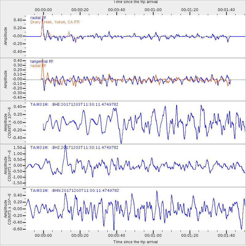
M31M Drury Creek, Yukon, CA - Earthquake Result Viewer
*The percent match for this event was below the threshold and hence no stack was calculated.
| Earthquake location: |
Near Coast Of Ecuador |
| Earthquake latitude/longitude: |
-0.5/-80.3 |
| Earthquake time(UTC): |
2017/12/03 (337) 11:19:06 GMT |
| Earthquake Depth: |
25 km |
| Earthquake Magnitude: |
6.0 Mww |
| Earthquake Catalog/Contributor: |
NEIC PDE/us |
|
| Network: |
TA USArray Transportable Network (new EarthScope stations) |
| Station: |
M31M Drury Creek, Yukon, CA |
| Lat/Lon: |
62.20 N/134.39 W |
| Elevation: |
639 m |
|
| Distance: |
74.5 deg |
| Az: |
336.787 deg |
| Baz: |
122.784 deg |
| Ray Param: |
$rayparam |
*The percent match for this event was below the threshold and hence was not used in the summary stack. |
|
| Radial Match: |
69.148254 % |
| Radial Bump: |
400 |
| Transverse Match: |
61.00267 % |
| Transverse Bump: |
400 |
| SOD ConfigId: |
13570011 |
| Insert Time: |
2019-04-29 08:58:39.364 +0000 |
| GWidth: |
2.5 |
| Max Bumps: |
400 |
| Tol: |
0.001 |
|
Signal To Noise
| Channel | StoN | STA | LTA |
| TA:M31M: :BHZ:20171203T11:30:11.474978Z | 3.3009348 | 3.4569774E-7 | 1.0472723E-7 |
| TA:M31M: :BHN:20171203T11:30:11.474978Z | 0.6180346 | 8.504997E-8 | 1.3761361E-7 |
| TA:M31M: :BHE:20171203T11:30:11.474978Z | 1.3009145 | 1.7057141E-7 | 1.3111654E-7 |
| Arrivals |
| Ps | |
| PpPs | |
| PsPs/PpSs | |


