You are here: Home > Network List > TA - USArray Transportable Network (new EarthScope stations) Stations List
> Station SFIN Lafayette, IN, USA > Earthquake Result Viewer
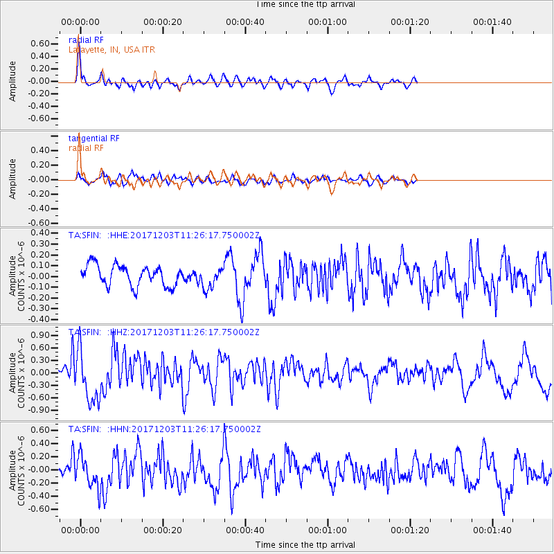
SFIN Lafayette, IN, USA - Earthquake Result Viewer
*The percent match for this event was below the threshold and hence no stack was calculated.
| Earthquake location: |
Near Coast Of Ecuador |
| Earthquake latitude/longitude: |
-0.5/-80.3 |
| Earthquake time(UTC): |
2017/12/03 (337) 11:19:06 GMT |
| Earthquake Depth: |
25 km |
| Earthquake Magnitude: |
6.0 Mww |
| Earthquake Catalog/Contributor: |
NEIC PDE/us |
|
| Network: |
TA USArray Transportable Network (new EarthScope stations) |
| Station: |
SFIN Lafayette, IN, USA |
| Lat/Lon: |
40.38 N/87.10 W |
| Elevation: |
165 m |
|
| Distance: |
41.1 deg |
| Az: |
352.081 deg |
| Baz: |
169.611 deg |
| Ray Param: |
$rayparam |
*The percent match for this event was below the threshold and hence was not used in the summary stack. |
|
| Radial Match: |
75.05101 % |
| Radial Bump: |
387 |
| Transverse Match: |
57.227734 % |
| Transverse Bump: |
400 |
| SOD ConfigId: |
13570011 |
| Insert Time: |
2019-04-29 08:58:56.166 +0000 |
| GWidth: |
2.5 |
| Max Bumps: |
400 |
| Tol: |
0.001 |
|
Signal To Noise
| Channel | StoN | STA | LTA |
| TA:SFIN: :HHZ:20171203T11:26:17.750002Z | 7.078394 | 6.444088E-7 | 9.103884E-8 |
| TA:SFIN: :HHN:20171203T11:26:17.750002Z | 2.512229 | 2.4734376E-7 | 9.84559E-8 |
| TA:SFIN: :HHE:20171203T11:26:17.750002Z | 1.1348122 | 1.0813779E-7 | 9.5291355E-8 |
| Arrivals |
| Ps | |
| PpPs | |
| PsPs/PpSs | |


