You are here: Home > Network List > TA - USArray Transportable Network (new EarthScope stations) Stations List
> Station Q20A Ridgley Place, Grand Junction, CO, USA > Earthquake Result Viewer
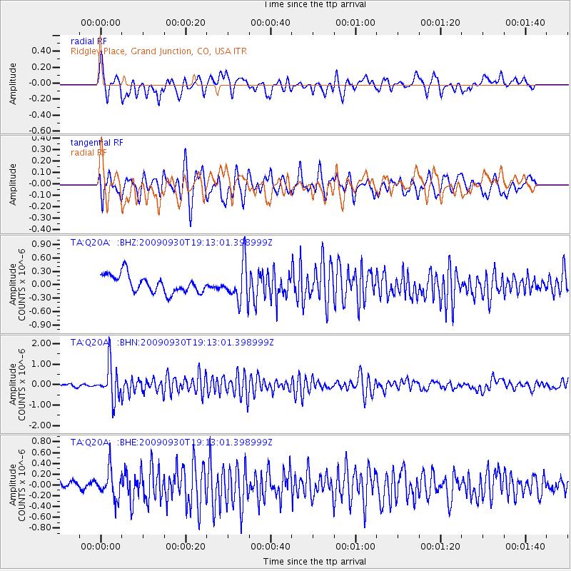
Q20A Ridgley Place, Grand Junction, CO, USA - Earthquake Result Viewer
*The percent match for this event was below the threshold and hence no stack was calculated.
| Earthquake location: |
Peru-Bolivia Border Region |
| Earthquake latitude/longitude: |
-15.6/-69.3 |
| Earthquake time(UTC): |
2009/09/30 (273) 19:03:17 GMT |
| Earthquake Depth: |
255 km |
| Earthquake Magnitude: |
5.9 MB, 5.8 MW |
| Earthquake Catalog/Contributor: |
WHDF/NEIC |
|
| Network: |
TA USArray Transportable Network (new EarthScope stations) |
| Station: |
Q20A Ridgley Place, Grand Junction, CO, USA |
| Lat/Lon: |
38.95 N/108.30 W |
| Elevation: |
1716 m |
|
| Distance: |
65.3 deg |
| Az: |
327.32 deg |
| Baz: |
138.128 deg |
| Ray Param: |
$rayparam |
*The percent match for this event was below the threshold and hence was not used in the summary stack. |
|
| Radial Match: |
56.8577 % |
| Radial Bump: |
400 |
| Transverse Match: |
69.357796 % |
| Transverse Bump: |
400 |
| SOD ConfigId: |
2622 |
| Insert Time: |
2010-03-06 07:12:42.368 +0000 |
| GWidth: |
2.5 |
| Max Bumps: |
400 |
| Tol: |
0.001 |
|
Signal To Noise
| Channel | StoN | STA | LTA |
| TA:Q20A: :BHN:20090930T19:13:01.398999Z | 12.308533 | 8.6610805E-7 | 7.0366475E-8 |
| TA:Q20A: :BHE:20090930T19:13:01.398999Z | 2.6139305 | 2.6717368E-7 | 1.0221147E-7 |
| TA:Q20A: :BHZ:20090930T19:13:01.398999Z | 2.2229564 | 4.3578768E-7 | 1.960397E-7 |
| Arrivals |
| Ps | |
| PpPs | |
| PsPs/PpSs | |


